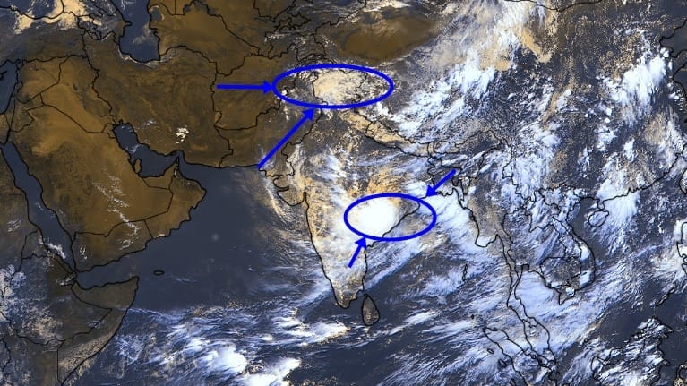
The India Meteorological Department (IMD) has issued a weather forecast predicting widespread rain, lightning, and strong winds across India through September 1. Regions including Delhi, Uttar Pradesh, Odisha, and the Northeast face heavy downpours. Authorities advise precautions against coastal squalls and urban waterlogging.
NEW DELHI — The India Meteorological Department (IMD) issued a national weather advisory predicting widespread rainfall, severe thunderstorms, lightning, and strong surface winds across large swathes of India through September 1.
The meteorology agency confirmed that a fresh atmospheric weather system will trigger localized heavy to extremely heavy rainfall over parts of North, East, Central, and Northeast India. Coastal areas are advised to prepare for thundersqualls with gusty winds reaching speeds of up to 70 km/h.
The latest operational update comes at a critical juncture for agricultural regions relying on late-season monsoon moisture. The IMD warned that intense, short-duration precipitation spells could cause local urban flooding, waterlogging in low-lying pockets, and transport disruptions across major transit corridors.
Regional Impact and Meteorological Breakdown
According to the weather department, active monsoon conditions are returning due to a low-pressure formation and favorable upper-air cyclonic circulations.
Northwest & Central India: Parts of Delhi-NCR, Uttar Pradesh, and Madhya Pradesh are projected to receive light-to-moderate showers interspersed with sudden heavy downpours.
Eastern Coast & Bay of Bengal: Odisha, West Bengal, and adjacent coastal pockets face severe weather marked by squally winds and electrical storms. Fishermen have been advised against venturing deep into offshore waters through the weekend.
Northeast States: Continuous moisture feed from the Bay of Bengal is set to sustain heavy rainfall over Assam, Meghalaya, and surrounding hilly terrain, elevating the risk of landslides and river overflow.
Direct Official Announcements
Statements released by national and state disaster response authorities outline key operational preparations:
"According to officials at the India Meteorological Department, localized weather alerts have been communicated to state disaster management authorities to ensure emergency teams remain on standby across vulnerable districts."
"Organizers and transport operators stated that suburban train services and regional flights may experience minor operational adjustments during peak downpours to maintain safety protocols."
Why It Matters
The IMD forecast carries significant operational and economic implications for citizens, municipal agencies, and key industry sectors:
Agriculture: Late-monsoon precipitation supplies essential soil moisture for standing Kharif crops (such as paddy, pulses, and oilseeds) while helping replenish rural water reservoirs before the winter season.
Urban Infrastructure: High-intensity rainfall in short timeframes places severe pressure on municipal drainage infrastructure, increasing urban flash flood risks in major metros.
Transportation & Travel: Commuters and logistics networks face potential delays due to waterlogged roadways, highway speed restrictions, and disrupted aviation schedules during heavy thunderstorm activity.
Key Facts at a Glance
Forecast Window: Active nationwide spell expected from August 26 through September 1.
Wind Speeds: Coastal regions could record wind gusts between 50 km/h and 70 km/h during thundersqualls.
Primary Regions Affected: Delhi-NCR, Uttar Pradesh, Madhya Pradesh, Odisha, West Bengal, and the Northeastern states.
Key Advisory: Citizens are urged to avoid taking shelter under isolated trees during lightning strikes and adhere to local municipal updates.
Frequently Asked Questions (FAQ)
Which states will see the heaviest rainfall until September 1?
The IMD forecasts the most intense rain activity over Odisha, West Bengal, parts of Madhya Pradesh, Uttar Pradesh, and Northeastern states like Assam and Meghalaya.
Will urban centers like Delhi experience major flooding?
Delhi-NCR is expected to witness intermittent light-to-moderate showers with short spells of intense rain. While widespread flooding is not forecast, localized waterlogging in low-lying transit points remains possible.
Are there travel or maritime warnings in place?
Yes. Fishermen and small vessel operators are advised to stay clear of the Bay of Bengal coastline due to strong winds reaching up to 70 km/h. Travelers should check regional road and flight updates during heavy downpours.
Source: India Meteorological Department (IMD), Ministry of Earth Sciences.