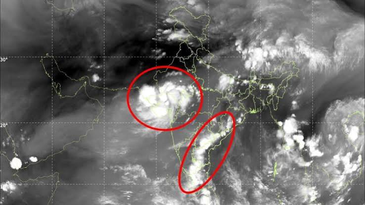
Satellites have captured twin weather systems driving late-season downpours across India, highlighting intense weather whiplash. While maritime moisture feeds active storms over western and central regions, meteorological indicators point toward the initial withdrawal of the southwest monsoon from Northwest India by September 19.
NEW DELHI — Advanced meteorological satellites operated by the Indian Space Research Organisation (ISRO), including INSAT-3DS, have captured a striking meteorological dichotomy across the subcontinent. Orbital thermal-infrared imaging reveals dual atmospheric engines operating concurrently over the surrounding seas, driving aggressive late-season rainfall across western, central, and eastern India even as the broader seasonal cycle approaches its transitional withdrawal phase.
The contrasting weather patterns, monitored closely by the India Meteorological Department (IMD), illustrate a classic late-monsoon configuration. While western and central regions experience a powerful final burst of heavy precipitation, southern peninsular zones are already exhibiting atmospheric traits tied to the upcoming seasonal shift.
Active Maritime Systems and Regional Contrast
Orbital tracking indicates that unsettled weather persists across both the Arabian Sea and the Bay of Bengal. Unsettled conditions along the Gujarat and north Maharashtra coasts are interacting with convective clusters originating from the northeast Arabian Sea. Simultaneously, active marine activity across the southeast and southwest Bay of Bengal, alongside the Andaman Sea, continues to pump high volumes of moisture inland.
This dual-system behavior underscores the complex mechanics governing the final weeks of the southwest monsoon. According to IMD observations, conditions are aligning to permit the formal withdrawal of the southwest monsoon from parts of West Rajasthan around September 19, marking the preliminary retreat of the seasonal trough from northwestern sectors.
According to official weather bulletins, satellite telemetry reports, and IMD advisories:
Arabian Sea Activity: Unsettled weather systems remain active along the Gujarat and north Maharashtra coastal belts, sustaining localized convective bursts.
Bay of Bengal Systems: Sustained moisture feeds and cloud bands continue to influence eastern and southeastern peninsular states.
Withdrawal Triggers: Conditions are turning favorable for the initial monsoon withdrawal from western segments of Northwest India by September 19.
Satellite Telemetry: High-resolution infrared radiometers on INSAT-3DS track cloud-top temperatures and atmospheric moisture channels in real time.
Official Sources Section
Quote Section
"According to meteorological updates and satellite tracking data, contrasting weather systems underscore the transitional nature of the current phase, bringing a final major burst of rain to western and central regions while southern states transition toward drier patterns."
Why It Matters
For agricultural planners and regional authorities, tracking late-season weather whiplash is essential for managing reservoir levels and securing maturing summer crops prior to the harvest period. For logistics and transport networks, sudden cloudbursts and convective activity require heightened vigilance along vulnerable highway and coastal corridors.
Key Facts at a Glance
Observation Tech: INSAT-3DS thermal infrared space imaging.
Active Zones: Arabian Sea coastline and Bay of Bengal corridors.
Milestone Date: Initial monsoon withdrawal expected around September 19, 2026.
Impact Areas: Western, central, and southern peninsular states.
FAQ Session
What do satellite images reveal about India's current monsoon patterns?
Satellite telemetry captures active dual marine weather systems operating across the Arabian Sea and Bay of Bengal, creating a distinct regional contrast of late-season downpours and early transitional drying.
When is the southwest monsoon expected to begin its withdrawal?
The India Meteorological Department (IMD) has indicated that conditions are becoming favorable for the monsoon to withdraw from parts of West Rajasthan around September 19, 2026.
Which satellite systems monitor these weather formations?
Indian meteorological satellites, including INSAT-3DS, utilize thermal infrared sensors to track cloud-top temperatures and moisture movement from space.
Where can citizens check official daily weather forecasts and warnings?
Updated weather maps, severe event alerts, and withdrawal progress notices are published via the India Meteorological Department Portal.
Source: India Meteorological Department, ISRO, India Today Science Desk, The CSR Journal