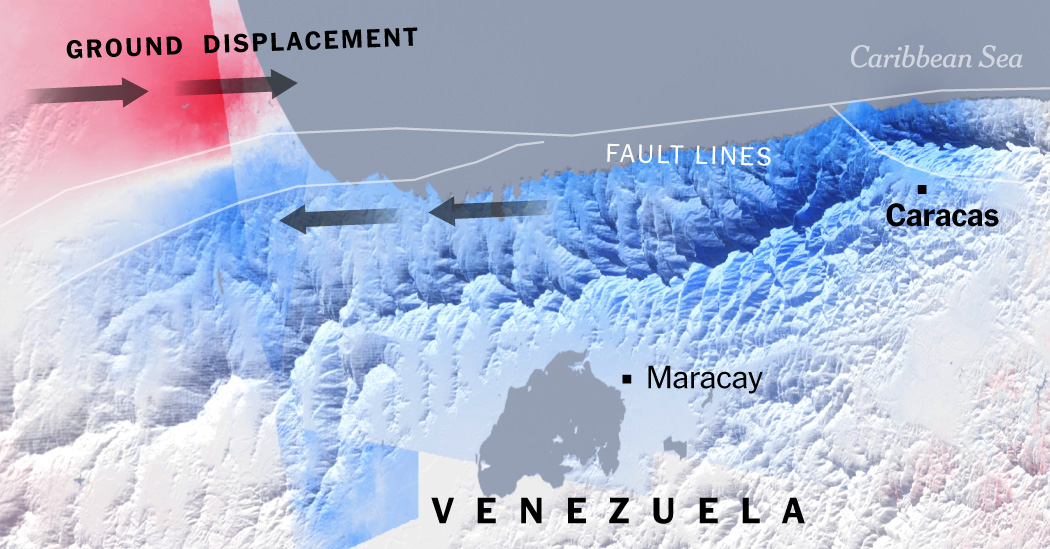
NASA satellite analysis has confirmed that the June 2026 twin earthquakes in Venezuela caused ground shifts of up to 60 centimeters. Using advanced radar imagery, scientists mapped the deformation along the San Sebastián Fault, providing critical data to assist in disaster response and structural risk assessments across northern Venezuela.
CARACAS, Venezuela — New satellite analysis from NASA has provided a harrowing look at the physical transformation of Venezuela’s northern landscape following the twin earthquakes that rocked the nation on June 24, 2026. Data captured by the NASA-ISRO Synthetic Aperture Radar (NISAR) satellite reveal that parts of the country’s coastline, including areas near the capital city of Caracas and the port of La Guaira, shifted by as much as 60 centimeters (approximately 24 inches).
The seismic event, which involved a magnitude 7.2 foreshock followed just 39 seconds later by a magnitude 7.5 mainshock, caused widespread destruction and significant loss of life. By comparing pre-quake imagery from mid-June with post-quake observations taken on June 25 and June 30, scientists were able to map the dramatic deformation of the Earth's crust along the San Sebastián Fault system.
Mapping the Seismic Rupture
The displacement maps were produced using Interferometric Synthetic Aperture Radar (InSAR), a technique that allows researchers to detect even minute changes in the Earth's surface by comparing repeat satellite passes. The resulting imagery displays distinct bands of movement, with the most intense horizontal displacement recorded in a zone south of the Simón Bolívar International Airport, north of Caracas.
Geophysicist Eric Fielding of NASA's Jet Propulsion Laboratory confirmed that the movement was primarily horizontal, a hallmark of the strike-slip faulting that characterizes the boundary between the Caribbean and South American tectonic plates. "This is why the damage in Caracas and La Guaira was so extensive," Fielding noted, explaining that the InSAR technology provides critical insights into the intensity and direction of the ground motion that contributed to widespread structural failure.
Implications for Disaster Response
The NISAR data was processed through the mission's "Urgent Response" system, which is designed to deliver preliminary satellite imagery within 12 to 24 hours of a natural disaster. This rapid deployment allowed the U.S. Geological Survey (USGS) to refine its "finite fault model," a tool used by emergency responders to understand how rocks displaced underground and which areas were most susceptible to the highest seismic energy.
Beyond the immediate search-and-rescue efforts, the satellite observations are helping geologists understand the long-term stress accumulation along the plate boundary. The San Sebastián Fault system, which has been accumulating strain for decades, experienced a sudden release of energy that permanently redrew portions of Venezuela's northern topography.
Official Sources
According to NASA’s Earth Observatory, the data captured by the NISAR satellite is part of a broader effort to improve seismic risk assessment. The U.S. Geological Survey (USGS) utilized the findings to better constrain how the fault slipped at depth, providing essential data for authorities coordinating the ongoing recovery and reconstruction projects in the affected states.
Why It Matters
For residents and businesses in northern Venezuela, the satellite data offers a scientific explanation for the localized nature of the destruction. By identifying the exact paths of surface rupture, planners can better assess the structural integrity of remaining infrastructure and prioritize high-risk zones for rebuilding. Furthermore, this mission represents a landmark for the NISAR program, as it marks the first time its rapid-response system has been deployed to map a major earthquake of this magnitude.
Key Facts at a Glance
Seismic Event: Twin earthquakes (magnitude 7.2 and 7.5) struck northern Venezuela on June 24, 2026.
Measured Displacement: Satellite data confirmed ground movement reaching 60 centimeters (24 inches) near Caracas and La Guaira.
Technological Tool: Scientists used InSAR (Interferometric Synthetic Aperture Radar) to compare satellite imagery and calculate crustal shifts.
Fault System: The movement occurred primarily along the San Sebastián Fault, a major boundary between the Caribbean and South American plates.
Frequently Asked Questions (FAQ)
What technology allowed NASA to track the ground movement?
NASA utilized the NISAR satellite and the InSAR technique, which compares radar images from before and after the earthquake to measure precise surface displacement.
Why was the ground displacement so significant?
The earthquakes involved high-energy strike-slip faulting where two tectonic plates slid past one another, resulting in rapid, horizontal shifts in the landscape.
How is this data used for recovery?
The data helps geologists and emergency responders identify where the fault ruptured and which areas experienced the most severe structural deformation, informing infrastructure risk assessments.
Source:
NASA Earth Observatory - Venezuela Earthquake Mapping
USGS Earthquake Hazards Program