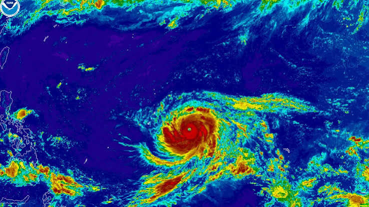
Super Typhoon Bavi, a Category 5-equivalent storm with 180 mph winds, is currently battering the Northern Mariana Islands and Guam. Officials have declared the situation life-threatening, warning of catastrophic structural damage, flash flooding, and dangerous surf as the storm tracks over the region on July 6, 2026.
Super Typhoon Bavi, a powerful Category 5-equivalent cyclone, made landfall over the U.S. territory of Rota on Monday, July 6, 2026, unleashing sustained winds of 180 mph. The National Weather Service (NWS) has characterized the storm as "extremely dangerous and life-threatening," as it continues to batter Guam and the Northern Mariana Islands with destructive force.
The storm’s arrival comes just months after the region was struck by Super Typhoon Sinlaku in April, leaving many communities still in the process of rebuilding infrastructure. With the eye of the storm tracking over Rota, officials are warning of near-total devastation for non-reinforced structures and widespread utility failures across the archipelago.
Catastrophic Impacts and Emergency Readiness
As of early Monday morning, the NWS confirmed that the western eyewall of Super Typhoon Bavi was moving directly over Rota, an island of fewer than 2,000 residents located northeast of Guam. The storm has brought torrential rains, with forecasts suggesting accumulations of 12 to 20 inches, significantly increasing the risk of flash flooding and landslides.
Guam Governor Lou Leon Guerrero transitioned the territory into a heightened state of emergency readiness, urging all 170,000 residents to remain in secure, interior rooms and away from windows. Meteorologists emphasize that the intensity of Bavi poses an "imminent danger to life," noting that flying debris from downed trees and collapsed power lines remains a primary threat to anyone venturing outdoors.
Meteorological Context
Designated a "super typhoon" due to sustained winds exceeding 150 mph, Bavi is currently ranked as one of the strongest storms globally in 2026. According to the Joint Typhoon Warning Center (JTWC), the storm’s environment has been highly favorable for maintaining its intensity, fueled by historically warm ocean temperatures in the western Pacific.
Forecasters warn that while the storm is moving at a relatively fast pace, its large size ensures that damaging tropical storm-force winds and life-threatening sea conditions—with waves potentially reaching 35 to 45 feet—will persist across the region through at least Tuesday.
Official Sources
National Weather Service (NWS) Guam: Providing real-time meteorological tracking and emergency warnings.
Joint Information Center (JIC): Official source for government emergency status updates, including Condition of Readiness (COR) declarations.
Joint Typhoon Warning Center (JTWC): Responsible for storm classification and intensity forecasting.
Quote Section
According to NWS meteorologist Marcus Landon Aydlett, "This is a powerhouse super typhoon, and this is going to be a very grim outlook for any island that takes a direct hit. It's going to be probably near catastrophic."
Why It Matters
For the 210,000 residents of Guam and the Northern Mariana Islands, Super Typhoon Bavi represents a major humanitarian and infrastructure challenge. The recurring nature of these extreme weather events—with two major super typhoons occurring in the same year—is straining recovery efforts, testing the resilience of local power grids, and leaving many residents in vulnerable housing conditions.
Key Facts at a Glance
Storm Intensity: Category 5-equivalent super typhoon with 180 mph sustained winds.
Primary Impact Zone: Rota, Tinian, Saipan, and Guam.
Flood Risk: 12–20 inches of rainfall forecast, with significant flash flood and mudslide potential.
Marine Conditions: Dangerous surf with breaking waves between 25 and 45 feet.
Emergency Status: All islands remain under severe weather warnings, with residents urged to shelter in place.
Frequently Asked Questions
1. What makes Super Typhoon Bavi "very dangerous"?
The storm is classified as a super typhoon with 180 mph winds. Meteorologists warn of life-threatening conditions, including flying projectiles, complete structural failure of non-reinforced homes, and dangerous storm surges.
2. When will the storm conditions subside?
While the eye passed over Rota early Monday, tropical storm-force winds and heavy rain are expected to continue across the region through Tuesday night.
3. Is there a relief effort underway?
Yes, local government agencies and the American Red Cross are active, though storm conditions have temporarily hampered the immediate deployment of large-scale disaster teams.
Source: National Weather Service (NWS) Guam, Guam Homeland Security/Office of Civil Defense, Joint Typhoon Warning Center (JTWC)