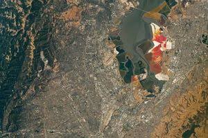
NASA has reported that the twin earthquakes which struck northern Venezuela in June 2026 caused the Earth's surface to shift by up to 60 centimeters. Data from the NISAR satellite helped identify the extent of the horizontal ground movement, providing crucial insights for disaster assessment, infrastructure planning, and seismic modeling efforts.
CARACAS — Following the destructive twin earthquakes that struck northern Venezuela on June 24, 2026, satellite analysis from NASA has revealed that the Earth’s surface shifted by as much as 60 centimeters (24 inches) in some coastal regions. The findings, released by NASA’s Earth Observatory, offer a precise look at the geological consequences of the seismic events that devastated areas near Caracas and La Guaira [1.1.1, 1.3.2].
The displacement data was acquired using the NISAR (NASA-ISRO Synthetic Aperture Radar) satellite, which utilizes Interferometric Synthetic Aperture Radar (InSAR) technology to map subtle changes in the Earth’s crust [1.1.2, 1.3.2]. By comparing radar imagery captured before and after the tremors, scientists identified significant horizontal ground movement along the San Sebastián fault system, a strike-slip fault boundary between the Caribbean and South American tectonic plates [1.1.3, 1.3.2].
Mapping the Seismic Aftermath
The dual earthquakes—measuring magnitudes 7.2 and 7.5—occurred less than a minute apart, causing widespread structural failure and loss of life across northern Venezuela [1.1.1, 1.3.1]. According to NASA geophysicists, the most intense displacement was recorded just south of the international airport north of Caracas, where the ground shifted approximately 60 centimeters [1.1.1, 1.3.2].
"This is why the damage in Caracas and La Guaira was so extensive," noted Eric Fielding, a geophysicist at NASA’s Jet Propulsion Laboratory (JPL) [1.1.1]. The InSAR technology, which can detect changes with millimeter-level accuracy, allowed researchers to visualize how the land moved east or west, providing a clearer understanding of the forces that triggered such severe destruction [1.1.2, 1.3.2].
Impact on Disaster Response and Planning
The data gathered by the NISAR satellite has been instrumental for organizations like the U.S. Geological Survey (USGS), which used the findings to refine its finite fault models [1.3.2]. These models help experts determine how energy was released underground, explaining why certain areas experienced greater devastation than others [1.1.1, 1.3.2].
For citizens and local authorities, this information is vital for long-term urban planning and assessing the structural integrity of remaining infrastructure [1.1.2]. By identifying regions where stress accumulated or shifted, experts hope to improve future risk assessments and bolster the safety of coastal developments [1.1.2].
Official Sources
The information regarding ground displacement and seismic analysis was provided by NASA’s Earth Observatory and the NASA-ISRO Synthetic Aperture Radar (NISAR) science team [1.1.1, 1.3.2]. The U.S. Geological Survey (USGS) provided concurrent data regarding the fault rupture models and seismic event details [1.1.3, 1.3.2].
According to officials, these maps were produced as part of the NISAR Urgent Response system, marking the first time this rapid-mapping process has been utilized following a major natural disaster to deliver preliminary satellite data within 12 to 24 hours [1.1.1, 1.3.2].
Why It Matters
This development highlights the critical role of space-based technology in modern disaster management. By providing high-resolution, objective data on physical landscape changes, satellite monitoring allows emergency responders to prioritize relief efforts and provides engineers with the data necessary to evaluate the stability of critical infrastructure in the wake of significant geological shifts [1.1.2, 1.2.4].
Key Facts at a Glance
Surface Shift: Ground displacement reached up to 60 centimeters (24 inches) south of the international airport near Caracas [1.1.1, 1.3.2].
Seismic Event: Two major earthquakes (M 7.2 and M 7.5) occurred on June 24, 2026, striking just seconds apart [1.2.4, 1.3.1].
Technology Used: NASA’s NISAR satellite used InSAR technology to compare surface conditions before and after the tremors [1.1.1, 1.3.2].
Fault Type: The quakes involved horizontal movement along a strike-slip fault system [1.1.1, 1.3.1].
FAQ
1. How did NASA measure the 60-centimeter shift?
Scientists used the InSAR technique, which compares radar satellite images taken before and after an earthquake to detect changes in the Earth’s surface with high precision [1.1.1, 1.3.2].
2. Why was the damage in Caracas and La Guaira so severe?
The high-resolution displacement data indicates that intense horizontal shifting of the Earth's crust occurred in these coastal regions, leading to extensive structural damage [1.1.1, 1.3.2].
3. Will this data help in predicting future earthquakes?
While earthquakes cannot be predicted, the data helps scientists understand fault line stress and behavior, which is essential for improving seismic models and long-term hazard assessment [1.1.2, 1.2.2].
Source: NASA Earth Observatory, U.S. Geological Survey, JPL (NASA)