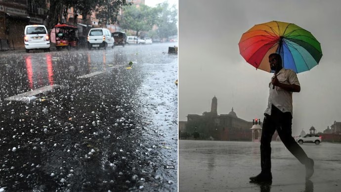
North India is bracing for a round of pre-monsoon weather activity a potent combination of duststorms, quick convective showers, and thundersqualls driven by hot, dry surface winds colliding with moisture from the Bay of Bengal. A fresh Western Disturbance is now building over the western Himalayas, set to intensify precipitation activity across the plains, hills, and northwestern states over the coming 48–72 hours.
The skies over North India have a message, and it is arriving fast. A combination of convective instability, a freshly energising Western Disturbance over Afghanistan and Pakistan, and a strong southwesterly moisture feed from the Arabian Sea and Bay of Bengal is setting the stage for one of May's classic pre-monsoon weather episodes duststorms, gusty squalls, and quick but intense showers that can bring dramatic relief from temperatures that have been running 3–5°C above normal across the Indo-Gangetic Plain. The India Meteorological Department (IMD) has issued alerts across multiple states as the system organises and moves eastward.
What Is A Western Disturbance And Why Does This One Matter
A Western Disturbance (WD) is an extratropical cyclonic circulation that originates over the Mediterranean Sea and travels eastward through Iran, Afghanistan, and Pakistan before impacting the Indian subcontinent. While Western Disturbances are most famous for bringing winter snowfall to the Himalayas and rain to the northwestern plains, the late-season May WDs are equally significant they interact with the pre-monsoon heat and moisture already present across North India to generate violent convective weather. This particular WD is assessed to be moderately intense, with its associated trough extending southeastward across Rajasthan, Haryana, and Punjab the classic configuration for triggering large-scale duststorm activity across the northwestern plains.
The Duststorm Threat: What To Expect
Duststorms locally called "andhi" in Hindi are among the most hazardous weather events of the North Indian summer. They form when strong convective downdrafts from thunderstorm cells hit the hot, dry surface and pick up loose soil and sand, generating walls of dust that can reduce visibility to near zero within minutes. Wind speeds during a major duststorm event can reach 60–80 kmph, with gusts occasionally exceeding 100 kmph in Rajasthan and the western UP belt. IMD has flagged Rajasthan, Punjab, Haryana, Delhi-NCR, and western Uttar Pradesh as the primary zones of duststorm risk over the next 24–48 hours. Residents are advised to stay indoors when the sky begins to turn orange or brown on the western horizon the classic visual warning sign that an andhi is approaching.
The Quick Shower: Relief And Risk Together
Following the duststorm phase sometimes simultaneously convective showers and thundersqualls are expected to sweep through the same region. These showers are typically short, lasting 20–45 minutes, but they can be intense bringing 15–30 mm of rainfall in a brief window, accompanied by lightning, thunder, and hail in isolated pockets over foothills and elevated terrain. For a region where daytime temperatures have been touching 44–46°C across Rajasthan and western Madhya Pradesh, even a brief shower can drop surface temperatures by 6–10°C within an hour a dramatic and welcome shift. However, the combination of sudden downpours and duststorm debris on roads creates serious waterlogging and reduced visibility hazards for commuters and vehicles, and the lightning risk is not trivial.
Delhi-NCR: What The Capital Can Expect
For Delhi-NCR specifically, the weather sequence is expected to unfold in a familiar pattern: afternoon heating building instability through the day, western skies darkening by late afternoon or early evening as the duststorm front approaches, followed by gusty winds, a brief sharp shower, and then rapid clearing by midnight. Temperatures in Delhi, which have been hovering between 41–44°C, are expected to drop to the mid-30s in the immediate aftermath of the shower event before climbing again as the system moves east. IMD has advised Delhi residents to avoid open areas during thunderstorm hours, secure loose outdoor objects, and be particularly cautious during the post-dust driving window when roads remain slippery.
The Himalayan Foothill Effect
The Western Disturbance's direct interaction with the Himalayas will be most pronounced across Uttarakhand, Himachal Pradesh, and Jammu and Kashmir, where moderate to heavy rainfall is expected over the next 48–72 hours, accompanied by snowfall above 3,000 metres in the higher reaches. Flash flood alerts have been issued for vulnerable river valleys including the Beas, Sutlej, and Yamuna tributaries. Cloudbursts intense localised rainfall events of 100 mm or more in under an hour are a specific risk in the Himalayan foothills during active Western Disturbance spells, and residents of hilly districts are advised to stay away from streams, rivers, and landslide-prone slopes.
Looking Ahead: Monsoon Approach Accelerates
This pre-monsoon episode is not isolated it is part of a larger atmospheric pattern that signals the Southwest Monsoon's strengthening approach. The monsoon has already reached the Andaman and Nicobar Islands on schedule and is expected to make its Kerala landfall around June 1, in line with its climatological normal date. The pre-monsoon thunderstorm activity across the north, far from being separate weather, is actually helping condition the atmosphere for the monsoon's eventual advance moistening soils, reducing albedo, and lowering the heat gradient that the monsoon's northward progression depends on. IMD's extended range forecast indicates that the monsoon may reach northwest India slightly ahead of its normal schedule in 2026.
Weather Watch Highlights
- IMD has issued duststorm and thunderstorm alerts for Rajasthan, Punjab, Haryana, Delhi-NCR, and western Uttar Pradesh for the next 24–48 hours
- A fresh Western Disturbance building over Afghanistan-Pakistan is the primary driver, interacting with pre-monsoon heat and Bay of Bengal moisture
- Duststorm (andhi) wind speeds may reach 60–80 kmph with gusts exceeding 100 kmph in Rajasthan; visibility could drop to near zero within minutes of onset
- Quick convective showers of 15–30 mm expected post-duststorm phase, capable of dropping temperatures by 6–10°C within one hour in affected cities
- Lightning, thunder, and isolated hail are likely across hilly and foothills regions of Uttarakhand, Himachal Pradesh, and Jammu and Kashmir
- Flash flood and cloudburst alerts issued for Beas, Sutlej, and Yamuna tributary valleys in the Himalayan foothills
- Delhi temperatures expected to drop from 41–44°C to the mid-30s immediately after the shower event, before rising again as the system moves east
- The Southwest Monsoon is on track for a timely Kerala landfall around June 1, 2026; IMD extended forecasts suggest a slightly early arrival in northwest India
- Residents advised to stay indoors during duststorm approach, avoid open areas during thunderstorm hours, and stay away from hilly streams and landslide zones
Sources: India Meteorological Department (IMD) alerts May 2026, Skymet Weather, Times of India Weather Desk, Hindustan Times Weather, NDTV Weather Report, IMD Extended Range Forecast May 2026


 Show more