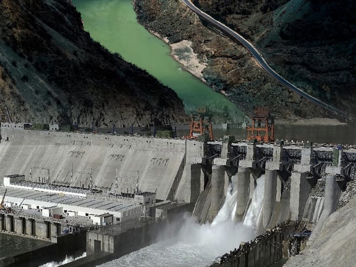
China's proposed 60,000 MW Medog mega-dam on the Yarlung Tsangpo River in Tibet has sparked significant safety and environmental concerns in downstream India and Bangladesh. Critics highlight seismic vulnerabilities and hydrological disruptions, while India accelerates counter-storage projects and demands greater transparency regarding transboundary water security.
NEW DELHI, INDIA — China’s advancing plans to construct a massive 60,000-megawatt hydropower installation on the Yarlung Tsangpo River in Tibet have heightened strategic, environmental, and hydrological concerns across lower riparian nations, particularly India and Bangladesh.
Known as the Medog Hydropower Station (or Motuo Hydropower Station), the proposed cascade project sits at the "Great Bend" of the Yarlung Tsangpo in Nyingchi Prefecture. The site lies just upstream from where the river crosses the Line of Actual Control into India’s Arunachal Pradesh, where it is known as the Siang, before joining the Brahmaputra River in Assam.
With a planned capacity triple that of China’s Three Gorges Dam, the project represents a major expansion of Beijing's renewable energy infrastructure. However, analysts and regional officials caution that the development could significantly alter transboundary water dynamics in South Asia.
Geological and Hydrological Risks in the Eastern Himalayas
Recent technical evaluations and geological studies published by researchers with the China Geological Survey have noted that the project area lies along active tectonic fault lines near the boundary of the Indian and Eurasian plates. Independent geologists have highlighted risks related to seismic activity, landslides, and potential slope instability in the Himalayan canyon.
From a hydrological standpoint, lower riparian stakeholders express concern that upstream storage facilities could affect seasonal river flows, disrupt essential silt transport vital for downstream agricultural floodplains, and limit real-time data sharing during extreme weather events.
To offset potential risks, India has accelerated planning for its own countervailing infrastructure, including the Siang Upper Multipurpose Project in Arunachal Pradesh, aimed at regulating water flow and expanding domestic storage.
Strategic Dynamics and Regional Implications
The Yarlung Tsangpo basin supports millions of livelihoods, agricultural ecosystems, and critical biodiversity zones in northeastern India and Bangladesh. Because China has not signed a formal multilateral water-sharing treaty with downstream neighbors, management of the river system relies primarily on bilateral memorandums of understanding and expert-level mechanisms for flood data transmission.
Diplomatic observers note that the construction of large-scale civil infrastructure near contested border zones adds a layer of complexity to broader bilateral relations between New Delhi and Beijing.
Official Sources Statement
According to official releases from the Ministry of External Affairs of India and statements from Chinese government representatives, discussions regarding transboundary river data sharing remain active through established diplomatic channels. Chinese foreign ministry officials maintain that planned installations are run-of-the-river designs intended to assist in energy generation and disaster mitigation, while Indian officials continue to advocate for transparent monitoring and protection of lower riparian rights.
Quotes
"According to officials from India's Ministry of External Affairs, the government continuously monitors all developments on transboundary rivers and regularly conveys its views and concerns to Chinese authorities to ensure that the interests of downstream states are not harmed by upstream activities."
Why It Matters
The Yarlung Tsangpo mega-dam project impacts energy policy, environmental management, and international diplomacy in South Asia. For farmers, fisheries, and urban communities along the Brahmaputra, sudden alterations in water flow or sediment supply directly affect food security and flood safety. For policymakers and investors, the project underscores the urgent need for robust, data-driven transboundary water governance frameworks in the ecologically fragile Himalayan region.
Key Facts at a Glance
Project Name: Medog (Motuo) Hydropower Station on the Yarlung Tsangpo River.
Proposed Capacity: Approximately 60,000 Megawatts (MW), capable of generating 300 billion kWh annually.
Geographic Location: Great Bend of the Yarlung Tsangpo, Nyingchi Prefecture, Tibet Autonomous Region.
Downstream Watercourses: Enters India as the Siang/Brahmaputra and flows into Bangladesh as the Jamuna.
Primary Downstream Concerns: Ecological impact, sediment flow interruption, seismic vulnerability, and water flow management.
Frequently Asked Questions (FAQ)
What is the Yarlung Tsangpo mega-dam project?
It is a planned 60,000 MW hydroelectric facility located on the Yarlung Tsangpo River in Tibet, designed by China to harness energy along the steep descent of the Great Bend canyon.
How does the Yarlung Tsangpo River connect to India and Bangladesh?
The Yarlung Tsangpo originates in Tibet, flows east through the Himalayas, turns south into Arunachal Pradesh (where it is called the Siang), flows through Assam as the Brahmaputra, and eventually enters Bangladesh as the Jamuna.
What are the main concerns raised by downstream nations?
Downstream nations have raised concerns regarding potential changes to seasonal water availability, reduced nutrient-rich silt deposition, increased seismic risks due to local geology, and the lack of a formal transboundary water-sharing treaty.
How is India responding to the development?
India is monitoring upstream activities, advocating for hydrological data transparency, and planning domestic water management and storage projects, such as the Siang Upper Multipurpose Project in Arunachal Pradesh.
Source: Official statements and releases from the Ministry of External Affairs of India, reports from the China Geological Survey, and public documentations from the Ministry of Water Resources of India.