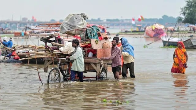
Rising water levels in the Ganga and Yamuna rivers have altered Prayagraj's geography, bringing the Sangam confluence point closer to the banks and low-lying areas near the Nagvasuki and Hanuman temples. The encroaching floodwaters have disrupted local businesses, forcing waterfront shopkeepers to relocate their stalls.
PRAYAGRAJ — The water levels of the Ganga and Yamuna rivers continued a steady upward surge in Prayagraj on Sunday, August 23, 2026, altering the local shoreline and forcing the prominent Sangam confluence point significantly closer to the banks. The rising rivers have inundated low-lying sectors near the Nagvasuki Temple and advanced toward the nearby Bade Hanuman Temple, disrupting local commerce, small vendors, and daily pilgrim operations across the riverfront.
Changing River Boundaries Encroach on Local Landmarks
Heavy monsoon precipitation across North India has led to elevated discharge across river systems, directly impacting the hydrology of Prayagraj. The advancing waters of both the Ganga and Yamuna have submerged traditional riverbed stretches, effectively compressing the distance between the holy confluence and peripheral structures.
According to field assessments and statements from residents, the geographical shift of the Sangam point is a recurring monsoon phenomenon, though the current volume of water has accelerated the riverfront's inward movement toward low-lying temples and commercial zones. Low-lying areas near the Nagvasuki Temple have recorded rising water levels, forcing shop owners and temporary stall operators to shift their setups further uphill to prevent property damage.
Impact on Local Businesses and Pilgrimage Activities
The changing shoreline has created operational bottlenecks for hundreds of local traders, boat operators, and shrine keepers whose livelihoods depend on tourism and daily religious visits at the Sangam. Vendors along the ghats report reduced foot traffic and ongoing logistical difficulties as water approaches fixed concrete structures and temple steps.
Local boatmen operating at the confluence have been forced to adjust landing points and modify navigation paths due to stronger currents and altered bank boundaries. While the movement of water brings the sacred confluence geographically closer to urban landmarks like the Bade Hanuman Temple, it simultaneously reduces available open space along the banks for ceremonial activities.
Official Sources Section
According to official updates from district administrative bodies and local authorities monitoring flood levels in Uttar Pradesh, water levels across both rivers are being tracked continuously. Emergency services, including disaster monitoring cells and river police units, remain on alert across low-lying stretches to evaluate safety protocols and assess the necessity of formal evacuation or containment measures.
Quote Section
"Organizers stated that..." the annual rise in river volume during the peak monsoon season routinely alters the physical layout of the Sangam ghats, requiring constant monitoring to ensure visitor safety and maintain order along low-lying riverbanks.
Local resident Rajesh Pandey noted the seasonal transformation during a public statement on Sunday: "The water levels of both the Ganga and Yamuna are rising. This happens every year. The water comes close to the Hanuman Temple. Earlier, the Sangam area was far, but as the water level rises, it comes closer to the Hanuman Temple. The rising water also affects local shops and businesses to some extent".
Why It Matters
The shift of the Sangam point highlights the immediate vulnerability of riverine economies and religious tourism infrastructure to seasonal monsoon fluctuations. With thousands of pilgrims visiting Prayagraj daily, water level changes directly dictate municipal safety operations, business continuity for small vendors, and logistical planning for regional disaster management teams.
Key Facts at a Glance
Geographical Shift: Swollen Ganga and Yamuna waters have pushed the Sangam confluence point closer to riverbank structures and the Bade Hanuman Temple area.
Inundation Zones: Low-lying regions, including areas surrounding the Nagvasuki Temple, face rising water levels.
Economic Disruption: Waterfront vendors, shopkeepers, and boat operators face operational shutdowns and relocation demands.
Administrative Response: Local authorities are actively monitoring river discharge levels to implement precautionary safety measures if required.
Frequently Asked Questions (FAQ)
Why has the Sangam point shifted in Prayagraj?
The confluence point of the Ganga and Yamuna rivers shifts geographically during the monsoon season as rising water levels submerge lower riverbed banks, bringing the waterline closer to fixed structures onshore.
Which areas in Prayagraj are currently affected by the rising water?
Low-lying stretches near the Nagvasuki Temple, the ghats surrounding the Bade Hanuman Temple, and commercial stall zones adjacent to the main Sangam banks are experiencing water encroachment.
How are local businesses in the Sangam area adapting to the floodwaters?
Shopkeepers and vendors are relocating their stalls to higher ground along the banks to prevent goods from being submerged, while boat operators are adjusting landing docks to account for altered currents and shorelines.
Source: Asian News International, Irrigation and Water Resources Department, Government of Uttar Pradesh