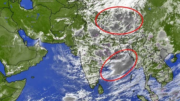
An intense weather convergence is bringing heavy rain today as two weather systems collide over India. The India Meteorological Department (IMD) reports that a deep depression over the Bay of Bengal has aligned with an active low-pressure vortex from the Arabian Sea, causing widespread deluge, flood risks, and severe travel disruptions across central, eastern, and northern states.
NEW DELHI — The India Meteorological Department (IMD) issued urgent weather warnings on Tuesday as two distinct monsoon systems collided over central and northern India. The simultaneous movement of a deep depression originating from the Bay of Bengal and a low-pressure vortex drawing moisture from the Arabian Sea has intensified rainfall across more than 17 states. Meteorologists warn that the combined atmospheric pressure will deliver prolonged downpours, elevating flash flood and landslide risks through the remainder of the week.
Atmospheric Convergence: How the Twin Systems Intersected
Satellite imagery captured by the Indian Space Research Organisation’s (ISRO) INSAT-3DR satellite shows two powerful circulation centers operating in tandem. The dominant system—a well-defined deep depression—crossed the Odisha and West Bengal coasts between Balasore and Canning before pushing inland toward Jharkhand and Chhattisgarh.
Simultaneously, a second cyclonic circulation over Rajasthan pulled a steady stream of moisture from the northern Arabian Sea. As the monsoon trough dragged both systems toward a central axis, their interaction formed an extended corridor of severe instability.
According to IMD synoptic charts, thermal infrared channels at 10.8 micrometers revealed a massive central dense overcast extending across eastern India, accompanied by cloud-top temperatures indicative of deep convective storm towers reaching the upper troposphere.
Regional Impact on Transit, Agriculture, and Urban Infrastructure
The collision of these weather fronts has led to widespread severe weather conditions across multiple sectors:
Eastern and Central India: Odisha, Gangetic West Bengal, Jharkhand, and Chhattisgarh face localized extremely heavy rainfall exceeding 200 mm within 24 hours. Disaster response teams in Odisha have been placed on high alert due to rapid runoff into major river basins.
Northern Plains & Capital Region: As the western arm of the monsoon axis swings northward, widespread rainfall is forecasted across Delhi, Punjab, Haryana, and western Uttar Pradesh. Surface transport and flight schedules at major hubs have experienced moderate delays due to reduced visibility and waterlogging.
Himalayan States: In Uttarakhand and Himachal Pradesh, the convergence of monsoon moisture with upper-level trough dynamics raises acute vulnerabilities to flash floods and mudslides over saturated topographies.
Western Coast and Gujarat: The Arabian Sea moisture surge continues to inundate low-lying regions in Gujarat, extending flood relief operations already underway.
Official Announcements and Safety Directives
According to official bulletins released by the Ministry of Earth Sciences, maritime authorities have strictly prohibited fishing operations along the northwest Bay of Bengal and coastal Odisha until atmospheric conditions stabilize. Coastal squally winds are projected to reach speeds between 55 km/h and 65 km/h, with gusts reaching up to 75 km/h.
"The interaction of two active circulation centers significantly accelerates moisture accumulation and cloud saturation," stated senior weather forecasters at the National Weather Forecasting Centre in New Delhi. "District administrations have been advised to monitor water levels in reservoirs and execute emergency drainage management in urban centers."
Why It Matters
When two low-pressure systems interact, precipitation intensity increases exponentially rather than linearly. The sudden discharge of water over saturated soil dramatically reduces soil stability, heightening risks for urban flooding, agricultural runoff, and critical infrastructure damage. For travelers and logistical operators, transport delays and river overflow present operational bottlenecks requiring immediate planning adjustments.
Key Facts at a Glance
Systems Involved: A deep depression over West Bengal-Odisha colliding with an Arabian Sea-fed low-pressure system over Rajasthan.
Peak Wind Speeds: Offshore squally winds reaching 55–65 km/h, gusting to 75 km/h.
Primary Threat Zones: Odisha, Chhattisgarh, West Bengal, Gujarat, Uttarakhand, and Himachal Pradesh.
Satellite Tracking: Monitored continuously via ISRO's INSAT-3DR and IMD meteorological radar networks.
Frequently Asked Questions
What causes two monsoon systems to collide over India?
A monsoon system collision occurs when two separate low-pressure vortices—typically one originating in the Bay of Bengal and another fed by the Arabian Sea—are drawn together by a southward-shifted monsoon trough. Their alignment pulls immense moisture from both oceanic bodies into a single land corridor.
Which states are under heavy rain alerts today?
The IMD has issued red and orange rainfall warnings for Odisha, West Bengal, Jharkhand, Chhattisgarh, Madhya Pradesh, Gujarat, Uttarakhand, Himachal Pradesh, and parts of the National Capital Region (Delhi-NCR).
How do satellite pictures help predict monsoon intensity?
Meteorologists analyze thermal infrared and visible spectrum satellite images from geostationary satellites like INSAT-3DR. White cloud shields indicate cold, high-altitude cloud tops (central dense overcast), pointing to severe updrafts and high rainfall potential.
What precautions should residents in affected regions take?
Residents in alert areas should avoid unnecessary travel, stay clear of low-lying flood-prone roads, monitor official alerts from municipal authorities, and secure livestock or machinery in hilly regions vulnerable to landslides.
Source: