The long-standing Teesta River dispute between India and Bangladesh remains deadlocked due to rigid political positions and a flawed focus on volumetric water allocation. To prevent seasonal collapses and secure local livelihoods, both nations must abandon zero-sum politics and transition to a collaborative, basin-wide environmental management framework.
As the 2026 deadline for the historic Ganga Water Treaty renewal approaches, the unresolved transboundary water dispute over the Teesta River between India and Bangladesh remains deadlocked. Decades of diplomatic friction have left over twenty million people vulnerable to alternating cycles of severe flash floods and dry-season droughts. Experts note that both New Delhi and Dhaka continue to treat the shared waterway as a political and mathematical calculation of volumetric water allocation, while ignoring the rapid ecological deterioration of the river basin itself.
Flawed Allocation Frameworks Fuel Bilateral Gridlock
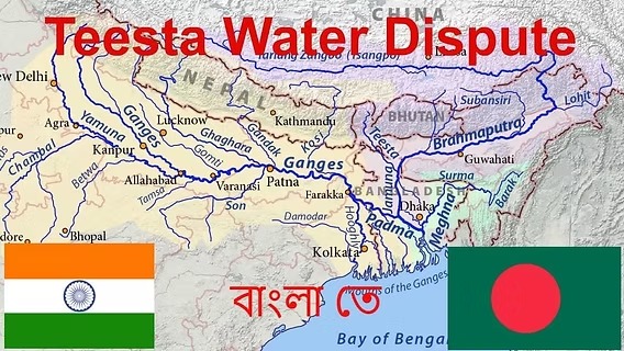
The Teesta River dispute centers primarily on the dry-season water flow between December and May. Bangladesh, the lower riparian state, has historically demanded a 50 percent share of the river's water supply to sustain its agricultural heartland. Meanwhile, India claims a 55 percent share based on its larger catchment area; roughly 83 percent of the Teesta’s basin lies within Indian territory, while the remaining 17 percent is in Bangladesh.
An interim 15-year arrangement drafted in 2011—which proposed allocating 42.5 percent to India and 37.5 percent to Bangladesh—was permanently shelved due to political opposition in the Indian state of West Bengal. Because water management is designated as a state subject under the Constitution of India, the central government cannot execute a transboundary treaty without the explicit consent of the frontline state.
This structural standstill has turned the river into a zero-sum geopolitical asset. Observers point out that looking strictly at volumetric sharing percentages fails to account for actual water availability. Upstream water withdrawals, combined with climate-driven glacial retreat in Sikkim, mean that the total volume of water reaching down to the plains is steadily diminishing.
The Infrastructure Trap: Barrages and Distorted Hydrology
Both countries have constructed massive infrastructure projects that severely alter the Teesta's natural hydrological flow:
The Gazaldoba Barrage (India): Built in West Bengal to divert water into the Teesta-Mahananda link canal for domestic agricultural irrigation.
The Teesta Barrage at Dalia (Bangladesh): Designed as a gravity-fed irrigation system for the country's northern plains.
During the dry winter months, upstream diversion at Gazaldoba reduces the downstream flow entering Bangladesh to a fraction of its historical volume. This leaves more than 100,000 hectares of arable land across five northern Bangladeshi districts severely degraded. Conversely, during the monsoon season from June to September, heavy rainfall and sudden water releases from upstream barrages spark catastrophic flash floods. This infrastructure-centric approach converts a continuous natural river system into an unpredictable, heavily engineered water channel.
Shifting From Water Volume to Basin-Wide Management
Environmental scientists and regional policy experts argue that an institutional overhaul is required to break the diplomatic impasse. Rather than debating static percentages of a shrinking water volume, negotiations must pivot toward comprehensive basin-wide management.
A joint hydrological strategy would focus on ecosystem preservation, sediment control, and joint flood-forecasting mechanisms. Furthermore, researchers suggest exploring shared benefits beyond agricultural water rights. India's upstream mountain terrain in Sikkim holds an estimated hydropower potential exceeding 6,500 megawatts. An integrated development framework could allow Bangladesh to trade for or invest in this clean energy capacity, compensating for its lower dry-season water yields and easing cross-border economic tensions.
Quote Section
"According to officials familiar with the Joint Rivers Commission briefings, the lack of synchronized, real-time hydrological data exchanges between the Gazaldoba and Dalia monitoring stations continues to severely hamper effective flood mitigation and equitable dry-season planning."
Why It Matters
The prolonged dispute directly impacts regional food security, agricultural supply chains, and geopolitical stability in South Asia. For millions of farmers in northern Bangladesh, the lack of water predictability destroys steady crop yields and drives localized economic migration. For investors and businesses, the geopolitical friction complicates transboundary transit initiatives, trade corridors, and regional energy grids connecting Bhutan, India, and Bangladesh.
Key Facts at a Glance
Catchment Distribution: Approximately 83 percent of the Teesta River basin lies within India, while 17 percent is situated in Bangladesh.
Agricultural Impact: Upstream water diversions during the dry season directly threaten the livelihoods of over 9 million people in the Teesta floodplain.
The 2011 Deal: The aborted interim agreement proposed a 42.5% share for India and 37.5% for Bangladesh over a 15-year period.
Hydropower Factor: India’s hilly upstream sections in Sikkim possess a projected hydropower development potential of over 6,500 MW.
FAQ Section
Why did the 2011 Teesta water-sharing agreement fail?
The interim agreement failed because the state government of West Bengal strongly objected to the text at the last minute. Under India's federal system, water is managed at the state level, preventing New Delhi from finalizing the treaty without local regional consent.
How does the Teesta dispute impact everyday citizens?
During winter, farmers in northern Bangladesh experience severe water scarcity that limits irrigation for essential rice crops. During the summer monsoon, sudden structural water releases upstream cause severe flash flooding, destroying homes and displacing thousands of families.
What is basin-wide river management?
Basin-wide management is an environmental approach that treats an entire river system as a single unit. Instead of just dividing water volumes at a border, it focuses on collaborative sediment control, ecosystem health, flood warning systems, and shared energy benefits across all nations involved.
Sources: