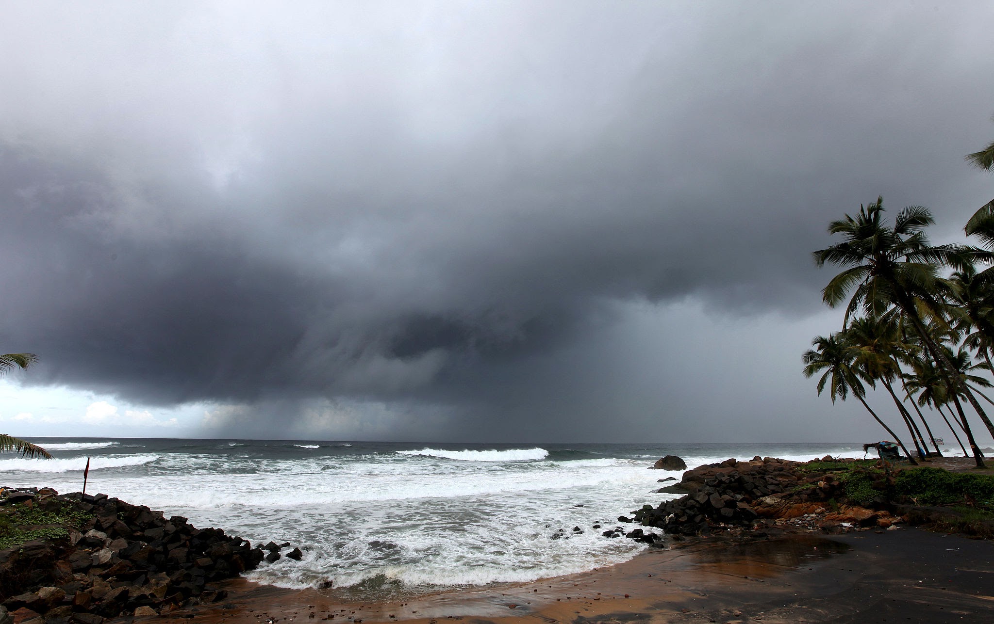
The southwest monsoon officially entered mainland India via Kerala on June 4, 2026. The state receives rain first due to its southwestern coastal positioning and the Western Ghats mountain range, which traps moisture-laden winds from the Arabian Sea, initiating India’s vital four-month agricultural and economic rainy season.
THIRUVANANTHAPURAM - The India Meteorological Department (IMD) officially confirmed the arrival of the southwest monsoon in Kerala on Thursday, June 4, 2026. While the onset took place three days later than the traditional standard date of June 1, the event reestablished a permanent meteorological truth: Kerala remains the undisputed entry point for the summer rainy season on the Indian mainland.
Understanding why Kerala is the first state in India to receive the rains involves looking at a precise mix of equatorial pressure shifts, maritime thermodynamics, and peninsular geography. For a nation where nearly 70% of annual rainfall is delivered during this four-month window, the mechanics behind this initial landfall carry immense weight for agricultural planning, food security, commodity markets, and rural economic growth.
The Physical Architecture of the Monsoonal Entry
The phenomenon that makes Kerala the primary gateway for monsoon rains centers on the seasonal reversal of winds, a process tied to the etymology of the word itself derived from the Arabic Mausim, meaning season. During late spring, the vast subcontinental landmass of northern and central India heats up much faster than the surrounding Indian Ocean. This extreme thermal variance creates an intense low-pressure zone over the plains, functioning as a massive atmospheric vacuum.
Simultaneously, a high-pressure system establishes itself over the cooler waters of the southern Indian Ocean. To correct this pressure imbalance, moisture-laden air masses begin a rapid journey northward toward the subcontinent. These winds, known originally as the southeast trade winds, cross the Equator and are deflected to the right by the Earth's rotation a phenomenon known as the Coriolis effect.
Reoriented as southwest monsoon winds, these currents sweep across thousands of kilometers of open ocean in the Arabian Sea, absorbing vast amounts of moisture. Because the Indian peninsula tapers to a sharp point at Cape Comorin, it splits the incoming oceanic airflow into two separate structural pathways: the Arabian Sea branch and the Bay of Bengal branch. The Arabian Sea branch makes its immediate, direct physical landfall along the southwestern coastline of India, squarely hitting the state of Kerala first.
The Western Ghats as an Orographic Barrier
While geographic location ensures that Kerala lies directly in the path of the incoming moisture corridor, the state's internal topography is what actively forces the air to release its moisture as torrential rain. Running parallel to the coast is the Western Ghats mountain range, which presents a high, continuous wall of elevation averaging between 1,200 and 2,500 meters.
As the dense, moisture-saturated southwest winds strike this mountain barrier, they undergo rapid orographic lifting a process where air is forced upward by the terrain. As the air rises, it expands and cools rapidly, causing the evaporated seawater to condense into massive rain-bearing clouds.
This mechanism triggers heavy, sustained precipitation along the windward side of the mountains, dousing Kerala’s coastal strips and highlands while leaving states on the leeward eastern side, such as Tamil Nadu, significantly drier during this phase.
Macro Impacts on Farmers, Supply Chains, and Inflation
The timely arrival and behavior of the rainy season over the southern coast serve as a critical economic bellwether for the rest of India. Agriculture accounts for roughly 14% of India’s gross domestic product (GDP) and employs over half of the national workforce. Because a massive portion of the country's arable land lacks artificial irrigation networks, multi-million dollar sowing cycles for critical summer crops including rice, pulses, cotton, sugarcane, and oilseeds are calibrated strictly to the movement of these winds.
The 2026 monsoon cycle has opened under a developing oceanic anomaly. The World Meteorological Organization (WMO) has cited an 80% likelihood of an El Niño climate pattern strengthening through the summer. Historically, El Niño correlates with weaker wind currents and below-normal rainfall over South Asia.
Consequently, the IMD has issued a long-range forecast predicting total seasonal rainfall to hover around 90% of the Long Period Average (LPA), placing it in the "below-normal" tier.
For commodity investors and retail consumers, any structural delay or deficit after the initial Kerala landing can quickly spark food inflation concerns. To counter potential supply shocks, central distribution agencies have reinforced reserves.
Official Sources Section
Data regarding wind velocity patterns, upper-air cyclonic circulations, and daily precipitation charts are sourced directly from the official bulletins published by the India Meteorological Department. Regional tracking statistics regarding agricultural preparedness and buffer inventories are maintained via statements from the Ministry of Agriculture and Farmers Welfare.
Quote Section
"According to officials at the India Meteorological Department's regional center, the criteria for declaring the formal onset over Kerala require that at least 60% of the 14 designated weather stations across the state and Lakshadweep record a minimum of 2.5 mm of rainfall for two consecutive days, accompanied by specific westerly wind depths and outgoing longwave radiation values."
Why It Matters
The dynamics of the monsoon's arrival dictate the immediate financial health of rural India. When the rains land predictably in Kerala and advance evenly across the interior, rural incomes rise, driving up consumer demand for automobiles, gold, electronics, and fast-moving consumer goods. Conversely, a weak or erratic monsoon strains power grids due to increased groundwater pumping, depletes hydro-electric reservoirs, and forces the government to implement export restrictions on essential food grains to preserve domestic price stability.
Key Facts at a Glance
Geographic Gateway: Kerala is the first mainland territory hit by the southwest monsoon due to its position as the southwesternmost point of the Indian peninsula.
Topographical Catalyst: The continuous ridge of the Western Ghats forces incoming maritime winds to rise and cool, triggering intense orographic rainfall along the coast.
2026 Onset Timeline: The monsoon officially arrived over Kerala on June 4, 2026, marking a short three-day deviation from the normal June 1 benchmark.
Climatic Headwinds: Global weather agencies highlight a strong El Niño presence, leading to an initial IMD projection of below-normal seasonal rainfall at 90% of the long-period average.
FAQ Section
Q1: Is Kerala the absolute first Indian territory to receive monsoon rain?
No. While Kerala is the first state on the mainland to receive the rains, the southwest monsoon actually hits the island territories of the Andaman and Nicobar Islands much earlier, typically around May 20.
Q2: Why doesn't the neighboring state of Tamil Nadu get heavy rain at the same time?
Tamil Nadu lies on the leeward side (the rain shadow region) of the Western Ghats. The mountains block the moist southwest winds, meaning Tamil Nadu receives the bulk of its rainfall later in the year during the northeast retreat of the monsoon.
Q3: How long does it take for the rains to travel from Kerala to Northern India?
After making landfall in Kerala, the weather system typically takes about six weeks to march across the country, generally reaching central states by mid-June and Delhi around June 27.
Source: India Meteorological Department, World Meteorological Organization Climate Centre, Ministry of Agriculture and Farmers Welfare