


Loading market data...
ADVERTISEMENT

Latest Top News
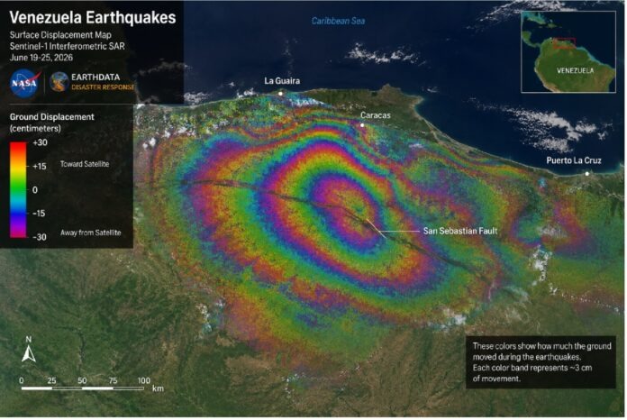
NASA Satellite Data Maps Significant Surface Shifts in Venezuela
NASA has released satellite-derived InSAR maps revealing that northern Venezuela's coastline shifted by up to 30 centimeters following the devastating June 2026 twin earthquakes. These high-resolution maps are currently being used by emergency responders to assess infrastructure damage and plan recovery efforts for nearly 59,000 affected structures.
Stay Ahead – Explore Now! Midwest Gold Approves 1:10 Equity Share Sub-Division
ADVERTISEMENT

Latest Updates

India, Japan Sign Pacts to Boost Cooperation in AI...
02 Jul 2026, 02:31 PM
Bank of Baroda Shares Fall 3.2% on $600M NMC Healt...
02 Jul 2026, 02:28 PM
Khadim India Approves ₹117.5 Million Convertible W...
02 Jul 2026, 02:13 PM
Panama Petrochem Gains Licence for New Factory in...
02 Jul 2026, 02:12 PM
Siyaram Recycling Industries Continues Winning Str...
02 Jul 2026, 02:11 PMADVERTISEMENT

Top Stories
India, Japan Sign Pacts to Boost Cooperation in AI...
02 Jul 2026, 02:31 PM
Bank of Baroda Shares Fall 3.2% on $600M NMC Healt...
02 Jul 2026, 02:28 PM
Khadim India Approves ₹117.5 Million Convertible W...
02 Jul 2026, 02:13 PM