


Follow WOWNEWS 24x7 on:


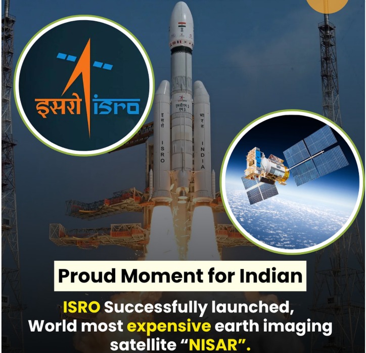
In a landmark moment for global space collaboration, India and NASA have successfully launched the NISAR satellite—a cutting-edge radar imaging observatory designed to monitor Earth’s land and ice with unprecedented precision. The satellite lifted off from the Satish Dhawan Space Centre in Sriharikota aboard ISRO’s GSLV-F16 rocket on July 30, 2025, marking the largest joint space mission between the two nations to date.
Key highlights from the launch and mission scope
1. Mission overview and technical specs
- NISAR stands for NASA-ISRO Synthetic Aperture Radar
- The satellite will orbit Earth at 747 kilometers in a near-polar path, scanning nearly all land and ice-covered surfaces every 12 days
- It is equipped with dual radar systems: NASA’s L-band and ISRO’s S-band, enabling detection of changes as small as one centimeter
- The satellite features a 30-foot boom and a 39-foot gold-plated mesh reflector, which will unfold over the next week
2. Scientific objectives and data applications
- NISAR will track melting glaciers, polar ice sheets, and shifting groundwater reserves
- It will monitor land deformation linked to earthquakes, landslides, and volcanic activity
- The satellite will also assess forest and wetland changes that influence carbon dioxide and methane emissions
- Data will be used to improve disaster forecasting and climate modeling, aiding governments and first responders worldwide
3. Collaboration and cost breakdown
- NASA contributed approximately 1.2 billion dollars, providing the L-band radar, reflector, and data systems
- ISRO’s share of 91 million dollars covered the S-band radar, satellite structure, and launch services
- The mission represents over a decade of collaboration between NASA’s Jet Propulsion Laboratory and ISRO’s technical teams
- Components were built separately and integrated at ISRO’s Satellite Integration & Testing Establishment in Bengaluru
4. Operational timeline and data access
- Science operations are expected to begin by the end of October 2025
- Data from NASA’s L-band radar will be available via the Alaska Satellite Facility
- ISRO’s S-band data will be distributed through Bhoonidhi at the National Remote Sensing Centre in Hyderabad
- The satellite will generate up to 80 terabytes of data daily, accessible to researchers and institutions globally
5. Strategic and geopolitical significance
- NISAR is the first satellite mission to use two radar frequencies for Earth observation
- It strengthens India’s position in low-cost, high-impact space missions and enhances its global scientific footprint
- The launch was attended by senior officials from both agencies, including NASA’s Casey Swails and ISRO’s V Narayanan
- Union Minister Jitendra Singh hailed the mission as a scientific handshake with the world, emphasizing its utility across aviation, shipping, and agriculture
6. Broader implications for Earth science
- NISAR’s ability to penetrate clouds, fog, and vegetation makes it a game-changer for environmental monitoring
- It will provide critical insights into ecosystem dynamics, infrastructure stability, and climate resilience
- The satellite’s data will support long-term studies of permafrost, biomass, and sea ice classification
- Its launch aligns with the priorities outlined in NASA’s 2007 decadal survey for Earth observation
Looking ahead
The successful deployment of NISAR signals a new era in Earth science, where international cooperation and advanced radar technology converge to decode the planet’s subtle shifts. As climate change accelerates and natural disasters grow more frequent, NISAR’s high-resolution data will be instrumental in shaping policy, protecting communities, and deepening our understanding of Earth’s evolving systems.
Sources: Associated Press, Hindustan Times, US News, MSN India, NASA Jet Propulsion Laboratory, ISRO, Times of India, Space.com, Phys.org


Follow WOWNEWS 24x7 on:


Copyright 2024 WOWNEWS 24x7. All rights reserved. The WOWNEWS 24x7 is not responsible for the content of external sites. Read about our approach to external linking.
Powered By Just Imagine
