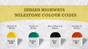
Ever noticed how milestones along Indian roads aren’t just plain stone markers but come in different colours? These aren’t just aesthetic choices—they’re part of a smart, standardized system that helps travelers and authorities identify the type of road they’re on at a glance.
What Do the Colours Mean?
-
Yellow & White Stripes: You’re on a National Highway. These are major roads connecting multiple states and cities, maintained by the National Highways Authority of India (NHAI).
-
Green & White Stripes: Welcome to a State Highway, managed by individual state governments. These roads connect cities and towns within a state.
-
Black/Blue & White Stripes: These indicate city or district roads, offering intra-district connectivity and maintained by local authorities.
-
Orange & White Stripes: You’re on a village or rural road, often built under schemes like the Pradhan Mantri Gram Sadak Yojana (PMGSY).
Why It Matters
-
Quick Navigation: Even without GPS, drivers can instantly know the road type and adjust expectations for speed, maintenance, and connectivity.
-
Administrative Clarity: Helps authorities manage jurisdiction, maintenance, and funding responsibilities.
-
Cultural Legacy: The system dates back to colonial times, with Nagpur once serving as the ‘Zero Mile Centre’ for measuring distances across India.
So next time you’re on the road, let the colours guide you—they’re more than just roadside décor.
Sources: Jagran Josh, India Today, Geography For You
