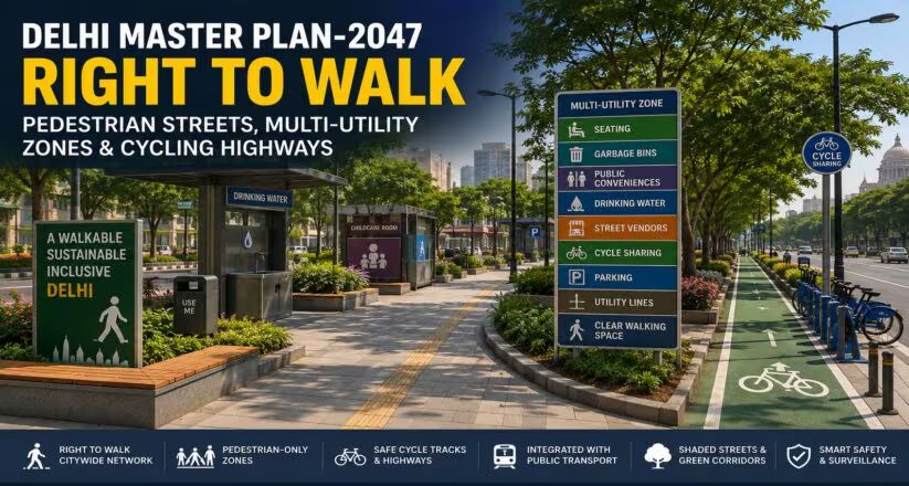
The Delhi Master Plan 2047 introduces a citywide "Right to Walk" framework, proposing dedicated pedestrian-only streets and multi-utility zones. Unveiled by the Ministry of Housing and Urban Affairs and the DDA, the initiative aims to curb vehicular dominance, clear pathway encroachments, and build safe, accessible urban pathways for commuters.
Backed by official urban planning releases, Delhi's Master Plan 2047 prioritizes pedestrian safety through dedicated walkways, multi-utility zones, and traffic-calming measures.
Reclaiming the Capital’s Streets for Pedestrians
In a significant shift toward people-centric urban design, the newly released Delhi Master Plan 2047 (MPD-2047) introduces a comprehensive citywide "Right to Walk" network. According to official announcements made by the Ministry of Housing and Urban Affairs and the Delhi Development Authority (DDA) in August 2026, the long-term blueprint seeks to address the reality that citizens walk an average of just 1.6 kilometers daily due to inadequate and obstructed walking infrastructure.
The framework responds directly to growing urban congestion and a recent Supreme Court emphasis on pedestrian safety. By integrating non-motorized transport (NMT) networks—which currently account for 42% of total city trips—authorities aim to establish safe, shaded, and universally accessible pathways connecting residential clusters, commercial hubs, and transit stations.
Multi-Utility Zones and Pedestrian-Only Corridors
To ensure clear, uninterrupted walking space, the master plan introduces Multi-Utility Zones (MUZs) along major roadways. These designated strips will house essential street furniture, including public seating, garbage bins, signage, drinking water stations, restrooms, childcare rooms, and organized spaces for street vendors.
Key infrastructure mandates outlined in the planning document include:
Pedestrian-Only Zones: High-footfall commercial areas, heritage precincts, and 24x7 economic districts will be designated as vehicle-free zones to encourage active travel.
Active Travel Networks: Continuous walking and cycling paths will be developed along major roads with a right-of-way exceeding 30 meters, as well as greenways along natural drains and the Yamuna riverfront.
Encroachment Clearance: The plan mandates the priority removal of unauthorized structures, illegal parking lots, and commercial encroachments from existing footpaths and NMT lanes.
Smart Traffic Calming: Installation of pelican crossings near schools and markets, supported by smart sensors providing real-time air quality data and safety surveillance.
Why It Matters
The implementation of dedicated pedestrian infrastructure directly impacts everyday commuters, local merchants, and city residents by enhancing road safety, reducing last-mile travel barriers, and transforming chaotic urban roadways into structured, sustainable public spaces.
Key Facts at a Glance
Policy Focus: Establishment of a citywide "Right to Walk" network under Delhi Master Plan 2047.
Baseline Data: Average daily walking distance stands at 1.6 km per resident.
Infrastructure Tool: Introduction of Multi-Utility Zones (MUZs) for street vendors, utilities, and public amenities.
Target Areas: Commercial hubs, heritage zones, and high-footfall transit corridors designated for pedestrian-only access.
FAQ Section
What does the 'Right to Walk' initiative entail under the Delhi Master Plan 2047?
The initiative establishes a network of safe, shaded, and universally accessible footpaths, pedestrian-only shopping zones, and active-travel corridors to prioritize walkers over private vehicles.
What are Multi-Utility Zones (MUZs)?
MUZs are designated roadside strips designed to house street furniture, utilities, public restrooms, drinking water facilities, and street vendors without obstructing pedestrian walkways.
How will commercial areas and heritage zones be affected?
High-footfall commercial districts and heritage precincts can be marked as pedestrian-only zones to promote cultural activity and safe retail shopping.
Where can citizens review the official Delhi Master Plan 2047 guidelines?
Comprehensive policy documents, zoning maps, and implementation updates are published through the Delhi Development Authority (DDA) Official Portal.
Source: Press Information Bureau (PIB), Delhi Development Authority (DDA) Portal, The Indian Express