India voted in favor of a UN General Assembly resolution titled "Correct the map" on September 5, 2026. The resolution seeks to phase out the 16th-century Mercator projection in favor of more accurate, equal-area representations. While backing fairer cartography, India emphasized the need for technological neutrality rather than endorsing a single map model.
Backed by official United Nations dispatches, the General Assembly has overwhelmingly voted to address historical size distortions in global map projections.
Signaling a major shift in international geographical standards, the United Nations General Assembly adopted the historic "Correct the Map" resolution on Friday, September 5, 2026. Sponsored by Togo on behalf of the African Group, the initiative passed with 164 votes in favor, one vote against from the United States, and six abstentions. India joined the vast majority of member states in voting for the resolution, which aims to correct long-standing cartographic biases inherent in the 16th-century Mercator projection.
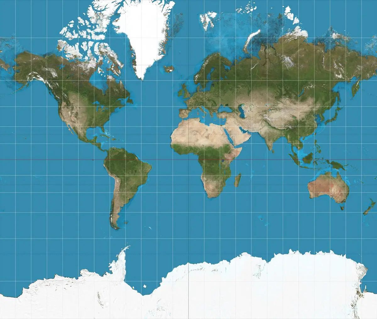
The resolution highlights that traditional flat maps distort landmasses far from the equator—disproportionately magnifying North America and Europe while minimizing the perceived sizes of Africa, Latin America, and South Asia.
Evaluating Cartographic Projections, Geographic Neutrality, and National Stances
Analyzing the diplomatic and technical details of the vote reveals a complex balance between historical accuracy and methodological flexibility. According to official UN statements and briefing records released on September 5, 2026, key parameters of India's stance include:
Support for Equal-Area Approaches: Delivering India's official explanation of vote, Raghoo Puri, First Secretary at India's Permanent Mission to the UN, stated that the country welcomed the goal of promoting more accurate and representative cartographic practices.
Technological Neutrality: India clarified that while it supports the broader use of equal-area map projections to preserve relative landmass sizes, it does not specifically endorse the "Equal Earth" projection or any single proprietary model.
Preserving Institutional Autonomy: New Delhi emphasized that different cartographic projections serve distinct navigational, educational, and digital purposes, ensuring countries and mapmakers retain the flexibility to select appropriate tools.
Addressing Cognitive Bias: The UN text stresses that historical map distortions carry cognitive, educational, and socioeconomic impacts that perpetuate unequal global perceptions.
Why It Matters
The practical implications of adopting more accurate map projections affect educational curricula, digital cartography software, global publishing, and international development frameworks. Traditional Mercator maps make landmasses like Greenland appear comparable in scale to entire continents such as Africa, distorting public perception of geographical scale. For educators, tech companies, and textbook publishers, transitioning toward equal-area maps fosters cognitive justice and geographic precision in classrooms and digital mapping platforms worldwide.
Key Facts at a Glance
Resolution Title: "Correct the map: rebalancing global cartographic representation and promoting equitable representation of the world's regions, particularly Africa."
Voting Outcome: Adopted by the UN General Assembly with 164 votes in favor, 1 against (US), and 6 abstentions.
Indian Representative: Raghoo Puri, First Secretary at India's Permanent Mission to the UN.
Core Objective: Phasing out navigational 2D distortions to accurately reflect continental landmass sizes.
FAQ Section
Why did the United Nations adopt the 'Correct the Map' resolution?
The UN adopted the resolution to address historical size distortions caused by the 16th-century Mercator map, which minimizes the perceived sizes of Africa, Latin America, and South Asia.
What was India's official stance on the UN map resolution?
India voted in favour of the resolution, supporting the use of equal-area map projections while emphasizing technological neutrality rather than endorsing any single map model.
How does the Mercator projection distort global maps?
Designed for navigation, the Mercator projection stretches landmasses near the poles (such as North America and Europe) while keeping equatorial regions at true scale, making continents like Africa appear much smaller than they actually are.
Where can readers verify the official UN voting records and statements?
Official voting tallies and delegate transcripts are archived through the United Nations Digital Library and verified international news networks.
Source: United Nations Official Document System, ANI News, The Hindu, Economic Times