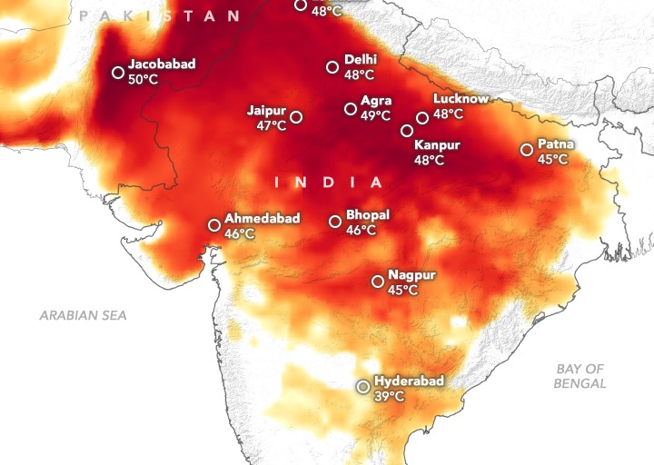
As India’s cities reel under intensifying heatwaves, a new wave of innovation is emerging at the intersection of climate resilience and digital intelligence. Leveraging artificial intelligence, satellite imagery, and geospatial mapping, Indian researchers and nonprofits are now pinpointing heat risks down to the level of individual buildings. The goal is urgent and clear: protect the urban poor—especially those living in informal settlements—from the deadly consequences of extreme heat.
Here’s how this cutting-edge approach is reshaping urban planning and public health in real time.
Key Highlights From The Initiative
- AI models like Sunny Lives, developed by SEEDS and Microsoft, are mapping indoor heat exposure across low-income homes
- Satellite data is being used to identify roof types and building materials, helping assess vulnerability without physical sensors
- Delhi’s 2025 Heat Action Plan is among the first to integrate such hyperlocal data into citywide emergency response
- Informal settlements near landfills and industrial zones are being prioritized for targeted interventions
How The Technology Works
The Sunny Lives model combines AI with satellite imagery and on-ground data to simulate how heat is experienced inside homes:
- It factors in roof material, building density, and surrounding land use to estimate indoor temperatures
- Tin-roofed homes, for instance, can reach 45°C indoors when outdoor temperatures are 40°C
- The model was trained using real-world data from homes in Delhi’s waste-picker communities, then scaled using satellite scans
This allows planners to identify which buildings are most at risk—without needing to install costly sensors in every home.
Why This Matters For India’s Urban Poor
India’s urban poor are disproportionately exposed to heat stress due to:
- Poor housing quality with inadequate ventilation or insulation
- Proximity to heat-amplifying zones like landfills, highways, and industrial belts
- Limited access to cooling infrastructure, healthcare, or early warning systems
By mapping heat vulnerability at the building level, cities can now:
- Prioritize distribution of cooling kits, water stations, and medical aid
- Design green corridors and shaded zones in high-risk neighborhoods
- Inform housing upgrades and climate-resilient urban design
Challenges And The Road Ahead
Despite the promise, several hurdles remain:
- Most of India’s 100-plus Heat Action Plans still lack granular heat mapping or vulnerability assessments
- Data gaps and limited coordination between municipal bodies and tech providers slow implementation
- Funding constraints make it difficult to scale pilot projects across all high-risk cities
However, experts believe that integrating AI-driven heat maps into smart city frameworks could be a game-changer—especially as climate change accelerates.
What To Watch Next
- Expansion of AI heat-mapping to cities beyond Delhi, including Ahmedabad, Hyderabad, and Chennai
- Integration of these tools into India’s Smart Cities Mission and urban health programs
- Development of a national heat stress index to guide long-term climate adaptation
As temperatures rise, India’s ability to protect its most vulnerable citizens may well depend on how quickly it can turn data into action. With AI and satellites now in the mix, the country is taking a bold step toward climate justice—one rooftop at a time.
Sources: PreventionWeb, Wired, AGI India, DigiTrendz, SEEDS India, Microsoft India, India Meteorological Department, NDMA India