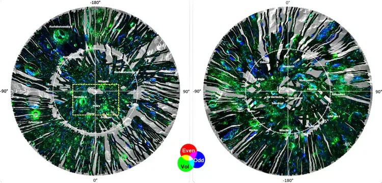
ISRO’s Chandrayaan-2 Orbiter has delivered groundbreaking radar images of the Moon’s polar regions, revealing potential water-ice deposits and detailed soil characteristics. Using advanced radar technology, scientists have created high-resolution mosaics that offer new insights into lunar surface composition and future exploration prospects.
India’s lunar mission unlocks polar mysteries
In a major scientific breakthrough, the Indian Space Research Organisation (ISRO) has released advanced data from Chandrayaan-2’s Dual Frequency Synthetic Aperture Radar (DFSAR), capturing high-resolution radar images of the Moon’s north and south poles. These images provide unprecedented detail on surface roughness, dielectric properties, and possible water-ice deposits—critical for future lunar missions and habitation planning.
The radar data, collected over five years, has been processed by ISRO’s Space Applications Centre (SAC) in Ahmedabad to generate full-polarimetric mosaics covering latitudes between 80° and 90° in both hemispheres.
Major takeaways:
-
Over 1,400 radar datasets were used to map the Moon’s polar regions
-
DFSAR is the first instrument to use L-band full-polarimetric mode at 25m resolution
-
Images reveal subsurface features, including potential water-ice and soil density variations
-
Data will aid global lunar exploration and ISRO’s future Moon missions
-
Peary Crater in the north pole featured prominently in the released imagery
Looking ahead
This dataset marks a significant leap in lunar science, positioning India as a key contributor to global space research and deep-space exploration.
Sources: Times of India, Business Standard, Republic World, India Today, Hindu BusinessLine