


Loading market data...
ADVERTISEMENT

Latest Top News
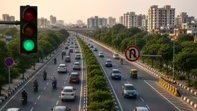
Delhi Plans 25 New Signal-Free Corridors to Ease Traffic
The Delhi government is advancing a plan to convert 25 busy road corridors into signal-free zones using a U-turn-based traffic management model. The initiative, supported by the Delhi Traffic Police and PWD, aims to reduce congestion and vehicle emissions by streamlining traffic flow across the capital by late 2026.
Stay Ahead – Explore Now! Rising from the Ashes: New Book Chronicles Founder Resilience
ADVERTISEMENT

Latest Updates

Anthropic in Early Talks With Samsung for Custom A...
03 Jul 2026, 03:35 PM
Delhi Schools Must Justify Fee Hikes on 18 Paramet...
03 Jul 2026, 03:16 PM
Renault Updates Kwid with New Logo and Two-Variant...
03 Jul 2026, 02:43 PM
Delhi to Build First Underground CBRN Command Cent...
03 Jul 2026, 10:26 AM
Lodha Developers Sets Sights on Gurugram Residenti...
03 Jul 2026, 09:09 AMADVERTISEMENT

Top Stories
Anthropic in Early Talks With Samsung for Custom A...
03 Jul 2026, 03:35 PM
Delhi Schools Must Justify Fee Hikes on 18 Paramet...
03 Jul 2026, 03:16 PM
Renault Updates Kwid with New Logo and Two-Variant...
03 Jul 2026, 02:43 PM