Google DeepMind’s India-developed agricultural AI models, ALU and AMED, are expanding to 11 nations across Africa and Asia. Utilizing satellite imagery and machine learning, these tools provide real-time field data, enabling automated crop monitoring, streamlined farm credit verification, and improved climate-resilient farming globally.
Google DeepMind’s India-first AI models for agriculture are rapidly expanding beyond domestic borders, providing spatial intelligence and high-resolution satellite analytics across 11 nations in the Asia-Pacific and African regions. Originally engineered by Google’s AnthroKrishi team to address India’s fragmented agricultural landholdings, the foundational models—Agricultural Landscape Understanding (ALU) and Agricultural Monitoring & Event Detection (AMED)—are now being deployed by governments, climate organizations, and private enterprises globally. The technology transition comes as international organizations seek scalable digital public infrastructure to boost crop yields, streamline credit access, and lower agricultural carbon emissions.
Technical Framework: ALU and AMED Core Architecture
The global expansion relies on two complementary artificial intelligence engines powered by remote sensing and satellite data analysis:
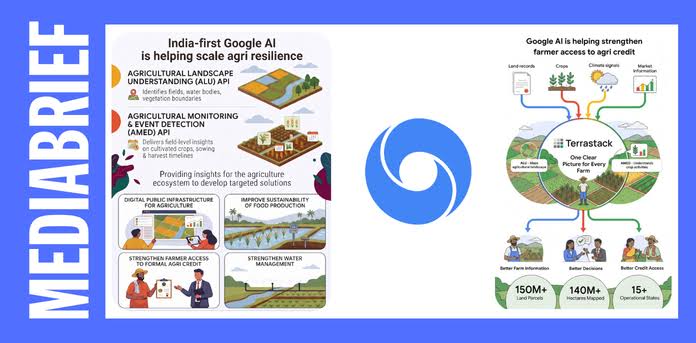
Agricultural Landscape Understanding (ALU): Delineates farm boundaries, distinguishes crop cover from wild vegetation, and tracks farm-level natural resources, including farm ponds and water bodies. The dataset has become one of the most widely used operational layers integrated into Google Earth.
Agricultural Monitoring & Event Detection (AMED): Operates on a 15-day satellite data refresh cycle, tracking active crop life cycles, planting patterns, harvest timing, and real-time stress indicators such as localized drought or pest disruptions.
By converting raw satellite imagery into machine-readable APIs, Google allows external platforms to map complex land parcels without requiring high-cost manual field surveys.
Global Expansion Across Africa and Asia-Pacific
First released for Indian farmland evaluation, the Google AI architecture has been deployed in African and Asia-Pacific countries. The expansion footprint includes Kenya, Uganda, Ghana, Rwanda, Nigeria, and Zambia, alongside early test deployments in Vietnam, Malaysia, Indonesia, and Japan.
According to Google DeepMind, the expansion aims to support smallholder farmers in regions with complex field boundaries similar to India's agricultural topology. The integration allows regional policymakers to replace paper-based field reporting with automated satellite intelligence.
Adoption in Indian Digital Public Infrastructure
In India, state governments and financial technology platforms are actively utilizing the APIs within public administration:
Telangana Agriculture Data Exchange (ADeX): The Telangana state government integrated ALU and AMED datasets into its public data exchange, supporting applications like Krishivaas, which delivers localized pest and weather advisories to over 5 million farmers.
Credit and Financial Verification: Private platforms like Terrastack have integrated the APIs across 140 million hectares of Indian farmland. This platform synthesizes satellite data with official land records to enable financial institutions to evaluate credit risk and issue loans faster.
Impact on Carbon Finance and Water Resource Management
Beyond crop advisories and credit scoring, the AI models are supporting climate initiatives. Global organizations like CarbonFarm use the models alongside Gemini to track low-carbon rice cultivation practices, verifying water conservation and reduced methane emissions across 12 countries. The automated data layer eliminates field inspection bottlenecks for farmers entering global carbon-credit programs.
Official Sources Section
According to official releases from Google DeepMind’s Research division, the AnthroKrishi team designed the foundational models to democratize spatial analysis for smallholder farming environments. Statements published by the Food and Agriculture Organization (FAO), Telangana’s Department of Agriculture, and participating agtech enterprises confirm ongoing integrations across public governance platforms and commercial agronomy apps.
Quote Section
According to official project leaders at Google DeepMind:
"Our India-first agricultural AI models are helping drive local impact and expanding to more countries and platforms... The agriculture ecosystem needs to develop targeted interventions to address present and future food security concerns."
Terrastack Chief Executive Officer Aaryan Dangi stated in an official blog release:
"Google's ALU and AMED models have enabled us to build a spatial intelligence platform that is helping transform fragmented land, crop, and income data into actionable intelligence for every farm in India."
Why It Matters
The global deployment of Google’s India-built AI models offers major practical benefits across the agricultural value chain:
For Farmers: Enables access to early disaster warnings, tailored crop management advisories, and simplified processing for bank credit.
For Lenders and Insurers: Cuts loan underwriting costs by replacing physical field visits with verified satellite imagery analysis.
For Governments: Strengthens national food security planning and climate policy execution using real-time crop monitoring.
Key Facts at a Glance
11+ Countries: Extends Google's India-developed AI tools across Africa and the Asia-Pacific region.
140 Million Hectares: Coverage area integrated by agricultural technology platforms using Google's APIs in India.
15-Day Data Cycle: Update frequency for the AMED model to monitor real-time crop development.
Google Earth Layer: The ALU dataset is now among the most accessed operational layers on Google Earth worldwide.
Frequently Asked Questions (FAQ)
What are Google's India-first agricultural AI models?
They are satellite-based machine learning tools—specifically Agricultural Landscape Understanding (ALU) and Agricultural Monitoring & Event Detection (AMED)—developed by Google DeepMind to analyze farmland boundaries and track crop growth patterns.
Which international countries are using these models?
The tools are being utilized and tested in 11 countries outside India, including Kenya, Uganda, Ghana, Rwanda, Nigeria, Zambia, Malaysia, Vietnam, Indonesia, and Japan.
How do these AI tools help individual farmers?
The underlying data powers third-party apps and government platforms that deliver field-level advisories on weather, pests, irrigation, carbon credits, and farm loan verification.
Source: Google DeepMind Official Research Announcements, Press Releases from the Government of Telangana, Terrastack Corporate Briefings.