The IMD issues yellow alert for Delhi-NCR for July 3, 2026, forecasting moderate rainfall, lightning, and gusty winds up to 50 kmph. Driven by active cyclonic circulations, the monsoon surge lowers temperatures but poses risks of waterlogging and traffic congestion across the national capital region.
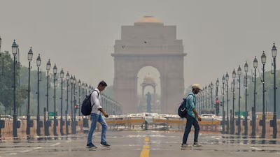
NEW DELHI — The India Meteorological Department (IMD) formally issued a yellow alert for Delhi-NCR on Friday, July 3, 2026, forecasting widespread moderate rainfall and severe thunderstorms across the national capital region. The dynamic weather update marks a major acceleration in the regional advancement of the southwest monsoon, which officially covered the entire capital territory earlier this week. As atmospheric systems strengthen, regional administrative bodies have been placed on high alert to handle potential urban flash floods, localized waterlogging, and significant disruptions to daily commuter traffic during peak hours.
Cyclonic Circulations Accelerate Seasonal Rain Activity
According to the latest daily forecast bulletin released by the regional meteorological center, the sudden increase in precipitation is driven by multiple overlapping atmospheric systems. A distinct low-pressure system lingering over the northwest Bay of Bengal, coupled with an active upper-air cyclonic circulation over southwest Uttar Pradesh, has systematically funneled moisture-laden winds directly toward the northern plains.
The weather office confirmed that these combined forces are expected to produce persistent overcast conditions through Friday evening. As the IMD issues yellow alert for Delhi-NCR, safety advisories indicate that lightning strikes and intense localized thundersqualls—with surface wind speeds reaching between 40 to 50 kilometers per hour—are highly likely to impact vulnerable open areas and suburban sectors.
Thermal Moderation and Urban Infrastructure Pressures
While the arrival of heavy showers provides much-needed relief from the oppressive humidity that pushed the region's heat index near 50 degrees Celsius earlier in the week, it creates operational pressures for city planners. State weather logs show that Safdarjung and surrounding observatories have already registered a noticeable temperature drop of 3 to 6 degrees Celsius over the past 48 hours, bringing daytime maximum temperatures down to a comfortable 33 degrees Celsius baseline.
However, civic organizations in New Delhi, Noida, and Gurugram are actively preparing for structural infrastructure challenges. Municipal corporations have deployed emergency pump sets to low-lying subways and chronically vulnerable underpasses, including the Minto Bridge corridor, to mitigate systemic water accumulation. Commuters are actively urged to check transit updates, as reduced visibility and water-choked junctions are expected to slow down traffic speeds across major commercial arterial routes.
Regional Impact on Travel and Agriculture
The footprint of this intense monsoon spell extends far beyond the capital lines. The broader regional forecast indicates that neighboring agrarian states, including Punjab, Haryana, and West Uttar Pradesh, are slated for widespread rainfall over the coming days.
For regional farmers, the well-distributed rainfall is a crucial boost for the ongoing Kharif sowing season, especially for water-dependent crops like paddy and maize. Conversely, the continuous downpours have triggered strict travel advisories for tourists heading toward the hill states of Uttarakhand and Himachal Pradesh, where corresponding orange and yellow warnings remain active due to heightened risks of sudden landslides and mudslides along major highway corridors.
Official Sources Section
The underlying meteorological matrices, systemic tracking models, and administrative warnings detailed in this emergency weather briefing are sourced directly from:
The national weather update portal operated by the India Meteorological Department (IMD).
Live telemetry feeds managed by the Regional Meteorological Centre (RMC), New Delhi.
Public travel safety notices circulated by the Ministry of Earth Sciences.
Executive Statements
"The India Meteorological Department has sounded a yellow alert for Delhi and its adjoining areas for July 3, Friday, forecasting a generally cloudy sky with moderate rainfall. Thunderstorms accompanied by lightning and gusty winds reaching speeds of 40–50 kmph are also likely at isolated locations."
— Official Statement, India Meteorological Department Bulletin
"According to officials from the municipal drainage division, pre-monsoon clearing protocols have been fully activated across all primary stormwater networks to ensure that high-volume downpours do not result in prolonged arterial road blockages."
Why It Matters
The implementation of the meteorological warning carries major daily practical implications:
For Office Commuters: High risks of localized waterlogging require early route planning to bypass traditional urban traffic chokepoints during rush hours.
For Aviation Passengers: Severe thunderstorm activity and high wind gusts can lead to temporary ground holding patterns and minor flight schedule adjustments at Indira Gandhi International Airport.
For Agricultural Markets: Adequate rain coverage across the northern plains stabilizes commodity futures by securing early crop establishment timelines.
Key Facts at a Glance
Alert Status: The IMD issues yellow alert for Delhi-NCR to caution the public against volatile, isolated severe weather changes.
Wind Dynamics: Thunderstorms are expected to trigger gusty surface winds reaching up to 50 kilometers per hour.
Temperature Drop: Continuous rain activity has successfully pulled maximum temperatures down by up to 6 degrees Celsius, providing vital cooling.
Wider Outlook: The intense monsoon surge is concurrently bringing widespread rainfall to Punjab, Haryana, and Western Uttar Pradesh.
FAQ Section
What does a yellow alert from the IMD signify for residents?
A yellow alert is a formal directive from the IMD advising residents to "be aware." It indicates that while the weather is not immediately hazardous, it has the potential to become severe, requiring people to monitor local updates before embarking on long commutes.
Will the rain lead to immediate flight delays at the Delhi airport?
Light to moderate rain generally does not disrupt modern aviation operations. However, if isolated thunderstorms produce severe lightning or visibility drops significantly below safe thresholds, brief tactical delays may occur.
How long is this wet monsoon spell expected to last in the national capital?
According to long-range satellite modeling, intermittent rain and thunderstorm activity are projected to continue daily across Delhi-NCR until at least July 7, 2026.
Source: India Meteorological Department (IMD) Official Site, Regional Meteorological Centre New Delhi, Ministry of Earth Sciences Bulletins.