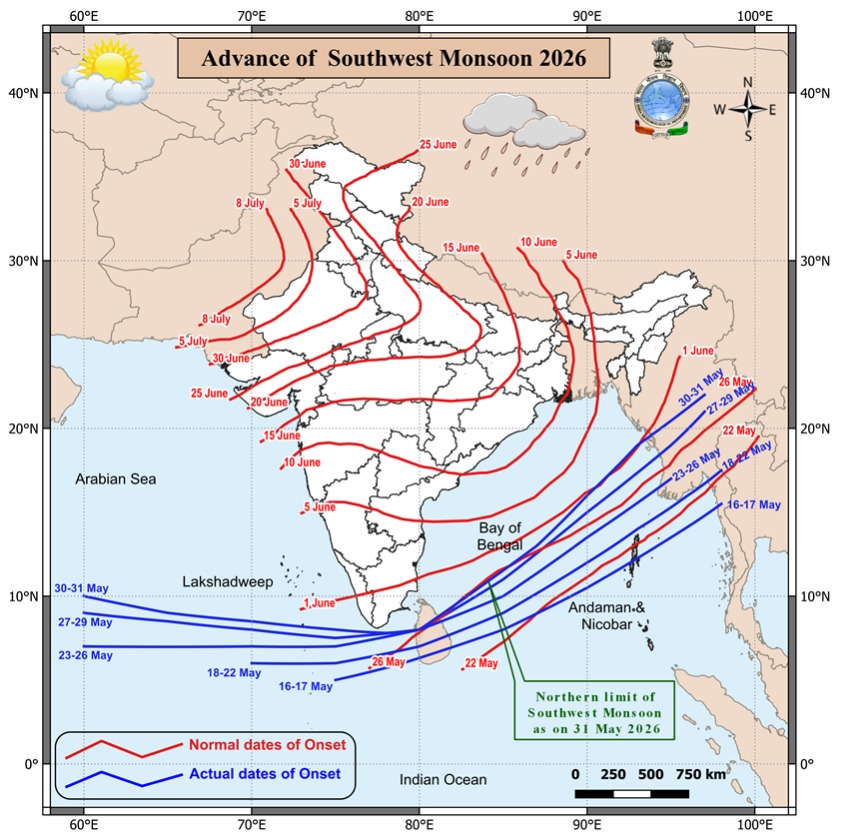
Rain and thunderstorms are sweeping across several parts of the country, with the India Meteorological Department saying that conditions are becoming increasingly favourable for further advance of the southwest monsoon in the coming days. The current spell is being driven by active weather systems over the Bay of Bengal and Arabian Sea, along with pre monsoon convection across central and peninsular India. IMD’s latest updates point to a wet first half of June for large swathes of the east, northeast and south.
IMD Signals Favourable Monsoon Conditions
In its recent press releases and extended range forecast, IMD has flagged isolated heavy rainfall over northeast India and south peninsular India during the week, along with thunderstorms and gusty winds at many places. These patterns, combined with strengthening westerly winds and cloud cover, are seen as supportive of the monsoon’s northward march from its initial foothold over the south. The department has also reiterated its long range guidance that the June to September 2026 southwest monsoon rainfall is likely to be broadly normal at the all India level.
Where The Rain Is Hitting Now
Daily rainfall bulletins show widespread light to moderate rain with isolated heavy falls over northeast states and parts of the southern peninsula, while scattered thunderstorms have lit up pockets of central and eastern India. Pre monsoon showers have brought some relief from heat in several locations, though humidity has climbed as moisture surges inland from both coasts. IMD’s extended forecast suggests that this unsettled pattern will persist into early June, with fresh spells expected as new low pressure systems brew over the adjoining seas.
How IMD Tracks Monsoon Progress
For formally declaring monsoon advance, IMD uses a mix of criteria, including rainfall at a specified network of stations, depth and strength of westerly winds and satellite based measures of cloudiness. The northern limit of monsoon is updated as the rain bearing system advances in surges, typically covering the entire country by mid July in a normal year. This year, forecasters are closely watching whether persistent convection and favourable winds allow the monsoon to keep pace with or slightly beat its climatological schedule.
Implications For Heat, Agriculture And Cities
As the rain belt expands, maximum temperatures are expected to ease in many regions, offering respite from the pre monsoon heat but replacing it with muggy conditions and localised flooding risks. For farmers, especially in rainfed belts, the timing and spatial spread of early June rains is critical for land preparation and sowing decisions for kharif crops. Urban bodies, meanwhile, are being advised to prepare for intense, short duration downpours that can overwhelm drainage in big cities at the very start of the monsoon season.
Key Highlights
- IMD reports rain and thunderstorms in many parts of India, led by active systems over land and sea
- Conditions described as favourable for further advance of the southwest monsoon in early June
- Isolated heavy rainfall likely over northeast India and south peninsular India during the week
- Long range forecast indicates broadly normal all India monsoon rainfall for June to September 2026
- Early season showers bringing heat relief but raising concerns on urban flooding and farm timing
Sources: India Meteorological Department