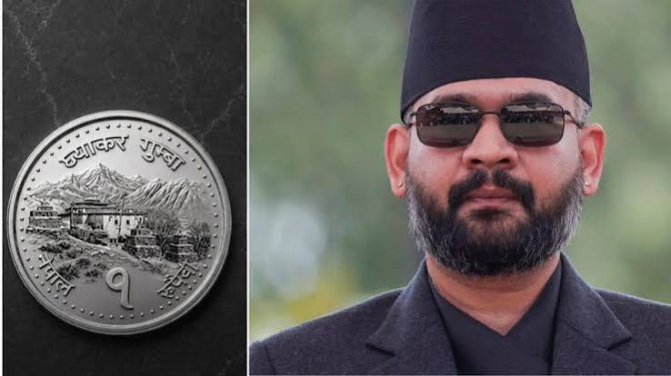
Nepal has confirmed that it will retain its updated political map featuring Lipulekh, Kalapani, and Limpiyadhura on its one-rupee coins. The decision reaffirms Kathmandu's territorial stance on the regions claimed by both Nepal and India, underscoring ongoing diplomatic sensitivities surrounding the 1816 Sugauli Treaty border interpretations.
KATHMANDU — Nepal's central bank, the Nepal Rastra Bank (NRB), and national authorities confirmed on Saturday, July 25, 2026, that the country will retain its updated political map featuring the disputed border territories of Lipulekh, Kalapani, and Limpiyadhura on its one-rupee coin currency mints. The move comes amid ongoing domestic policy debates and political pressure surrounding currency redesigns, re-affirming Kathmandu’s official territorial stance despite objections from New Delhi, which maintains that the regions are an integral part of Uttarakhand state in India.
This development is important today as it highlights the continued diplomatic sensitivity surrounding border demarcation between the two South Asian neighbors, impacting bilateral ties, trade discussions, and diplomatic engagements.
Currency Mints and Political Map Continuation
The dispute centers on the inclusion of the 335-square-kilometer region encompassing Lipulekh, Kalapani, and Limpiyadhura in Nepal's official cartography. Following internal evaluations regarding coin resizing and metal composition changes, official deliberations concluded that the political map including the three territories will remain represented in national currency production runs.
According to officials from the Nepal Rastra Bank, currency specifications are periodically reviewed to reduce minting costs and adjust metal composition. However, decisions regarding territorial depictions on legal tender remain strictly aligned with the political map officially adopted by the Parliament of Nepal.
Context and History of the Border Dispute
The cartographic tension dates back to May 2020, when the Nepalese government officially amended its constitution and published an updated political map. The update added Lipulekh, Kalapani, and Limpiyadhura to Nepal’s administrative boundaries following India’s inauguration of an 80-kilometer road connecting Dharchula in Uttarakhand to the Lipulekh Pass for the Kailash Mansarovar pilgrimage route.
Nepal's Position: Nepal bases its claim on the 1816 Treaty of Sugauli signed with British India, arguing that the Mahakali (Kali) River forms the western international boundary and that the river's origin lies east of Limpiyadhura.
India's Position: India rejects the claim, asserting that the administrative and revenue records of the 19th century establish the boundary along different ridge streams, placing Kalapani and Lipulekh under Pithoragarh district in Uttarakhand. India has consistently termed unilateral map alterations as an "artificial enlargement" of territorial claims.
Impact on Citizens, Trade, and Regional Relations
The border issue carries practical implications for local communities living along the 1,850-kilometer open border between India and Nepal. While day-to-day cross-border movement, trade, and cultural exchanges continue under the 1950 Treaty of Peace and Friendship, public political gestures on legal tender regularly stir nationalistic debates in both capitals.
For travelers and traders, official cross-border transit points remain open, but diplomatic observers note that currency depictions of contested zones keep bilateral boundary negotiations in a delicate state.
Official Sources
According to official announcements, government releases, and regulatory statements:
The Nepal Rastra Bank (NRB) oversees the design, metal specifications, and minting schedules of all domestic coins and banknotes.
The Ministry of External Affairs, India has maintained that unilateral actions regarding territorial maps do not alter ground realities or established bilateral boundary dialogue frameworks.
Official cabinet records from the Government of Nepal affirm that national currency designs reflect constitutional map provisions adopted by Parliament.
Official Statements
"According to officials, currency minting protocols strictly adhere to constitutional maps and regulatory framework guidelines established by the government," state central bank communications.
Why It Matters
Currency issues involving disputed territories directly impact diplomatic relations and economic sentiment between India and Nepal. For policymakers and citizens, maintaining stable bilateral ties is vital for regional energy projects, cross-border infrastructure, and trade corridors linking the Himalayan nation to Indian sea ports.
Key Facts at a Glance
Territories Involved: Lipulekh, Kalapani, and Limpiyadhura located near the India-Nepal-China tri-junction.
Currency Action: Nepal retains the updated national map on its legal tender coins.
Historical Reference: The dispute stems from differing interpretations of the 1816 Sugauli Treaty regarding the origin of the Kali River.
Administrative Reality: India administers the Kalapani region as part of the Pithoragarh district of Uttarakhand.
Frequently Asked Questions
Which territories are featured on Nepal's coin map?
The map depicts Lipulekh, Kalapani, and Limpiyadhura, located at the northwestern tri-junction of India, Nepal, and China.
What is India's official stance on Nepal's revised currency map?
India maintains that the territories are part of Uttarakhand and has described unilateral map updates as "artificial enlargement" that cannot alter ground realities.
Which treaty defines the India-Nepal international boundary?
The 1816 Treaty of Sugauli, signed between the Kingdom of Nepal and British India, established the Kali River as Nepal's western boundary.
Source: Nepal Rastra Bank, Ministry of External Affairs, India, Government of Nepal