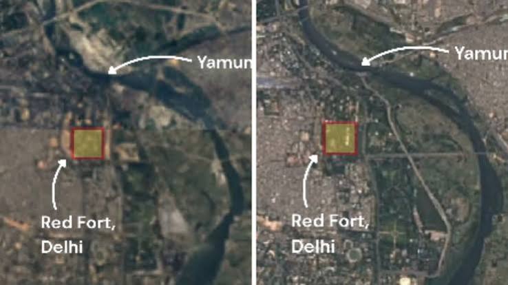
A 225-year study by the University of Delhi and IISER Bhopal reveals the Yamuna in Delhi has lost 68% of its width and 89% of its water flow since 1799. This degradation, driven by barrages and urban encroachment, has significantly increased the city's vulnerability to flooding and ecological collapse.
NEW DELHI – A landmark study has revealed that the Yamuna river flowing through Delhi has narrowed by nearly 68% and suffered an 89% decline in water volume over the last 225 years. The research, titled "Two Centuries of Hydrogeomorphic Changes: Width-Discharge Dynamics of the Urbanised Yamuna River in Delhi," was conducted by scientists from the University of Delhi’s Department of Geology and the Indian Institute of Science Education and Research (IISER), Bhopal.
Using archival maps dating back to 1799—specifically a map by Upjohn preserved at the National Archives of India—combined with historical records and modern satellite imagery, the researchers reconstructed the river’s transformation. The study provides a stark view of how Delhi’s rapid expansion has altered its lifeline.
Human Intervention vs. Natural State
The study concludes that the dramatic transformation of the Yamuna is primarily the result of human intervention rather than natural geological shifts. Researchers identified several key factors driving this decline:
Barrages and Flow Diversion: The construction of multiple barrages, including Tajewala (1873), Okhla (1874), Wazirabad (1959), and ITO (1966-67), has diverted vast amounts of water upstream, significantly reducing the natural flow reaching Delhi.
Encroachment on Floodplains: Embankments built for flood protection have disconnected approximately 45 square kilometres of floodplains from the river between 1912 and 2024. These areas have largely been repurposed for urban development and agriculture.
Urbanization Pressures: Delhi’s population explosion, growing from roughly 2.5 lakh in the early 19th century to over 2.15 crore in 2024, has placed unprecedented demands on land and water resources.
Ecological and Urban Risks
The researchers highlight that the river’s degradation is now a significant urban risk. By constraining the river into a narrower channel, its natural ability to absorb floodwaters has been severely hampered. The study cites the July 2023 floods as a prime example, where the river recorded high water levels despite lower upstream discharge compared to historical flood events, because the river’s channel could no longer accommodate the volume.
Furthermore, the loss of sandy mid-channel islands—which shrank from 20 square kilometres in 1985 to just 4 square kilometres in 2020—signals a collapse of the habitats that once maintained the river’s ecological balance.
Official Sources
University of Delhi (Department of Geology): Co-author of the hydrogeomorphic study.
Indian Institute of Science Education and Research (IISER), Bhopal: Co-author of the hydrogeomorphic study.
National Archives of India: Provider of the 1799 Upjohn archival map used to reconstruct the river’s natural state.
"According to officials, the study concludes that sustained human interventions over the past two centuries have transformed the Yamuna into a significantly narrower and lower-flow river, reducing its resilience to flooding and other extreme weather events".
Why It Matters
This research marks a shift in the discourse surrounding the Yamuna. While much public focus has been on pollution and water quality, this study emphasizes that structural changes—such as narrowing and floodplain disconnection—are equally critical. Restoring the Yamuna’s resilience will require moving beyond simple pollution control to include the restoration of natural flow regimes and the reconnection of vital floodplains.
Key Facts at a Glance
Width Reduction: The average bankfull width shrunk from ~658 metres in 1799 to ~210 metres in 2024.
Discharge Decline: The volume of water flow dropped from ~30,000 cubic metres per second in 1799 to ~3,900 cubic metres per second in 2024.
Floodplain Loss: ~45 square kilometres of floodplains have been disconnected from the river since 1912.
Channel Bars: Habitat-rich mid-channel islands declined by 80% between 1985 and 2020.
Frequently Asked Questions
1. What is the primary cause of the Yamuna's decline?
The study attributes the decline to human interventions, specifically the construction of barrages, embankments, and rapid urban expansion, rather than natural changes.
2. How did researchers track these changes?
They reconstructed the river’s history using a rare 1799 map, combined with historical records and modern data from Landsat and Sentinel-1 satellites.
3. Why does the river face higher flood risks now?
Because the river has been narrowed and its floodplains restricted, it has lost the space needed to spread out during high-flow events, causing water levels to rise more sharply.
4. Can pollution control alone save the river?
No, researchers argue that restoring the Yamuna requires protecting natural flows and reconnecting floodplains, not just cleaning the water.
Source: Geological Society of India, Financial Express, The Tribune