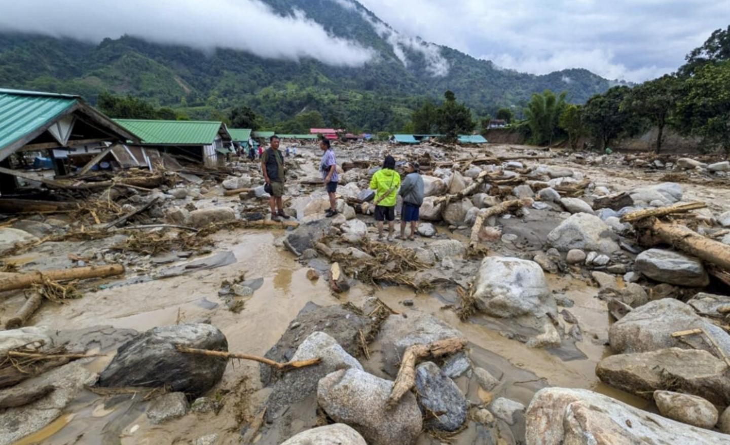
An intense cloudburst-like spell of heavy rainfall triggered devastating flash floods in Arunachal Pradesh's Keyi Panyor district, destroying up to 18 homes in a NEEPCO staff colony and leaving five people missing. The resulting landslides have completely blocked National Highway-13, isolating six western districts from the rest of the state.
ITANAGAR, India — Torrential rainfall and subsequent flash floods caused widespread destruction across the Keyi Panyor district of Arunachal Pradesh on Wednesday, June 24, 2026. The extreme weather event inundated low-lying areas, destroyed critical infrastructure, and left at least five people missing.
According to updates issued by the Arunachal Pradesh State Disaster Management Authority, the sudden deluge was triggered by a highly concentrated spell of rain during the early hours of Wednesday. The localized cloudburst-like event caused the Possa River to rise rapidly, overflowing its banks and sending torrents of mud and water through residential and commercial zones. The severe disruptions have completely isolated multiple districts in the Western Zone of the state, prompting the immediate mobilization of national and state rescue forces.
Retaining Wall Failure Ravages NEEPCO Residential Colony
The most severe structural impact occurred in the Poosa area near the Yazali circle, where floodwaters breached the residential colony of the North Eastern Electric Power Corporation (NEEPCO). Dispatches from district administrative teams indicate that an under-construction concrete retaining wall gave way under the immense hydrostatic pressure of the swollen river.
The structural failure allowed a massive wave of mud, boulders, and river water to sweep directly into the low-lying sections of the staff quarters. Preliminary damage assessments confirm that between 15 and 18 semi-permanent residential units were either heavily compromised or completely washed away. Following the inundation of its staff colony and adjacent facilities, NEEPCO authorities temporarily shut down operations at the Panyor Lower Hydroelectric Project (formerly known as the Ranganadi Hydroelectric Project) and opened a spillway gate by 1.5 meters to release excess water at a rate of 230.83 cubic meters per second.
Landslides Sever Transportation Networks and Isolate Districts
Beyond the immediate river basin, heavy rainfall triggered severe mudslides and slope failures along the region's mountainous transport corridors. Large volumes of debris engulfed portions of the Trans-Arunachal Highway, blocking vehicular movement at three major locations.
The Ministry of Road Transport and Highways lines were cut off along the main ICR-Hoj-Yazali National Highway, leaving dozens of passengers and vehicles stranded near Potin and Hoj. State officials confirmed that the Hoj bridge and junction, which provide essential connectivity to Pakke Kesang and East Kameng districts, have been entirely severed. Because of these cumulative blockages, six districts in the Western Zone—including Upper Subansiri, Kamle, Lower Subansiri, Kurung Kumey, Kra Daadi, and Keyi Panyor—are currently cut off from the state capital.
Downstream Alerts Issued for Neighboring Assam
The rapid accumulation of water in the upper catchment areas of the Eastern Himalayas has created an emergency situation downstream. The volume of water moving out of the Panyor project has forced the Assam state government to issue an immediate high alert across its northern boundaries.
Water resource registers indicate that the sudden surge is expected to raise the levels of the Brahmaputra River and its tributaries within the next 24 to 48 hours. Flood control stations in neighboring Assam have placed seven downstream districts—including Dhemaji, Lakhimpur, Biswanath, Sonitpur, and Dhubri—on heightened alert, mobilizing local rescue boats and preparing relief camps to accommodate displaced families.
Official Sources Section
Emergency statistics and infrastructure statuses are sourced directly from situational bulletins published by the Disaster Management Department of Arunachal Pradesh and the Assam State Disaster Management Authority. Weather observation logs are verified by data from the India Meteorological Department (IMD) regional tracking center in Itanagar.
Quote Section
"According to officials coordinating the emergency response, search and rescue operations are facing severe logistical constraints on the ground because the primary helipad in the affected area has suffered structural damage, preventing the immediate landing of military transport helicopters."
Why It Matters
The flash floods in Keyi Panyor highlight the vulnerability of infrastructure in the steep terrains of the Eastern Himalayas during intense monsoon phases. For civil engineers and town planners, the collapse of the retaining wall underscores the critical need for reinforced structural standards for flood protection barriers near hydroelectric zones. Furthermore, the complete isolation of six districts emphasizes the necessity of developing alternative communication lines and redundant transport routes to prevent large populations from being stranded during extreme weather events.
Key Facts at a Glance
Concentrated Rainfall: Yazali recorded 72.8 mm of rain within 24 hours, with the vast majority falling during an intense three-hour window between 6:00 AM and 9:00 AM.
Colony Inundation: The collapse of an under-construction retaining wall allowed the Possa River to destroy 15 to 18 residential quarters at the NEEPCO colony.
Missing Persons: Emergency teams have formally identified five individuals missing from the project area, with search and rescue operations currently underway.
Power Station Shutdown: Operations at the Panyor Lower Hydroelectric Project have been completely suspended, with a spillway gate opened to manage the sudden water surge.
Regional Isolation: Major landslides along National Highway-13 have effectively cut off six western districts from the rest of Arunachal Pradesh.
Frequently Asked Questions
What caused the flash floods to be so destructive in Keyi Panyor?
The destruction was caused by a high volume of rainfall falling within a short three-hour period over the steep terrain of the Eastern Himalayas. This caused immediate water runoff into local streams, which overwhelmed an under-construction retaining wall near the NEEPCO colony.
Which transport routes are currently closed to the public?
The primary ICR-Hoj-Yazali National Highway (NH-13) is closed due to massive landslides at three distinct locations. Additionally, the critical Hoj bridge junction connecting Pakke Kesang and East Kameng has been completely cut off.
How are rescue operations being managed despite the road blockages?
Personnel from the State Disaster Response Force (SDRF) and National Disaster Response Force (NDRF) have been deployed on the ground. However, operations are currently limited to foot travel and local vehicles because the damaged regional helipad has temporarily halted aerial support.
Source: Arunachal Pradesh State Disaster Management Portal, India Meteorological Department Weather Bulletins, Assam Government Flood Control Desks.