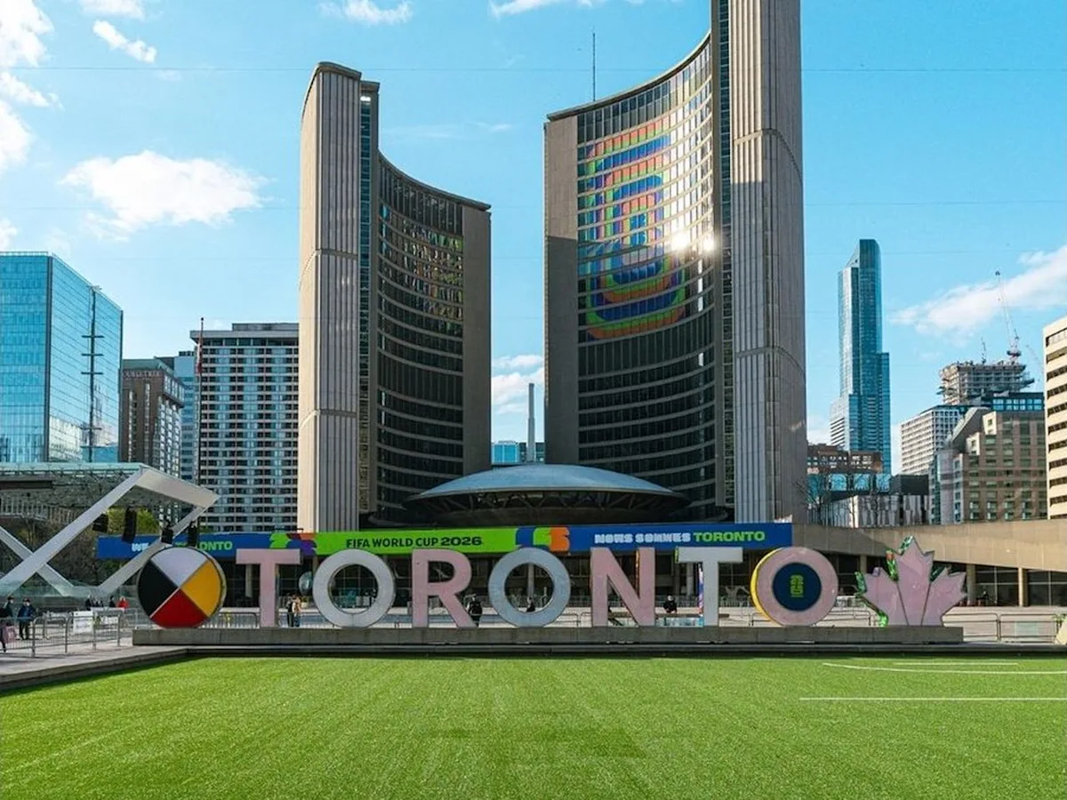
The official Canadian host city frameworks outline distinct experiences for visiting soccer fans. Toronto offers a sprawling, multicultural urban environment centered around Nathan Phillips Square, while Vancouver presents a highly walkable, dense downtown core integrated directly with the scenic mountains and waterways of the Pacific coast.
TORONTO and VANCOUVER — The official operational profiles for Canada's dual host cities have been established, framing the cultural and geographic parameters for international soccer fans arriving for the tournament. Based on municipal and tourism registers published via Yahoo News Canada, detailed logistical configurations have been finalized for Toronto and Vancouver.
This infrastructure mapping is fundamentally important today as global ticket holders begin coordinating international travel routes, cross-border accommodations, and matchday schedules. Understanding the distinct neighborhood networks and transit anchor points of each metropolis is necessary to ensure safety, minimize localized transit delays, and optimize municipal crowd control during peak tournament operational windows.
Toronto: A Diverse Urban Center and Neighborhood Network
According to municipal architectural archives and regional tourism statements, Toronto is structured as a sprawling, highly populated metropolitan zone characterized by a vast network of multicultural neighborhoods. The city's multi-ethnic demographic profile means that arriving international supporters will find established local communities representing nearly every competing global nation.
The operational layout for incoming travelers highlights specific metropolitan hubs:
A primary focal point for public gatherings and fan interactions in the city is Nathan Phillips Square. Situated directly outside Toronto City Hall, the square serves as the central structural anchor for public activations, municipal events, and urban navigation, offering direct access to the city's commercial core, extensive food sector, and tourist corridors.
Vancouver: Integrating Dense Modern Infrastructure with Nature
In contrast to the dense industrial footprint of eastern urban centers, the western host city of Vancouver offers a distinctly different environmental layout. Regional planning documents detail a coastal metropolitan design that seamlessly integrates a dense, modern downtown core with immediate, unhindered access to natural wilderness.
The geographic profile of the western host city balances two primary environments:
| Regional Environmental Matrix | Primary Local Asset | Core Visual & Logistical Feature |
| Dense Modern Infrastructure | Downtown Business District | Easily Navigable Walkable Grid |
| Immediate Natural Wilderness | Pacific Ocean Coastline & Mountains | Direct Waterfront Access Pathways |
Tourism authorities emphasize that the city's layout is shaped heavily by its outdoor culture. The downtown peninsula is bounded by water and scenic mountain ranges, providing visitors with a highly walkable environment where coastal recreation areas sit directly alongside primary commercial and hospitality infrastructure.
Official Sources Section
The cultural descriptions, neighborhood designations, city hall gathering parameters, and regional geographic breakdowns detailed in this news report are compiled directly from published tournament travel briefs and host city profiles indexed by Yahoo News Canada.
Quote Section
"According to officials tracking international tourist arrivals, the dual-city setup highlights the vast geographic and cultural variety of the country. Arriving fans will experience a distinct contrast between the multi-ethnic neighborhoods of a major financial center and the outdoor, nature-focused layout of the Pacific coast."
— Regional Tourism Alliance Logistics Brief
Why It Matters
The distinct structural differences between Canada's host cities carry practical implications for incoming international travelers and local transport systems. For fans, recognizing that Toronto relies on a sprawling neighborhood grid while Vancouver features a highly compact, walkable waterfront core allows for more accurate budgeting of daily transit times. For local businesses, these layouts dictate how customer foot traffic flows, helping retail and hospitality businesses manage inventory and staffing around central hubs like Nathan Phillips Square or downtown waterfront walkways.
Key Facts at a Glance
Central Toronto Hub: Nathan Phillips Square, situated outside City Hall, acts as the primary public gathering anchor for visitors.
Multicultural Framework: Toronto's vast neighborhood network offers incoming fans direct access to diverse global communities and varied culinary scenes.
Dual Environments: Vancouver’s layout is distinguished by an immediate transition from a dense downtown infrastructure to mountains and ocean.
Walkable Design: The western host city utilizes a compact coastal plan that connects urban centers directly to scenic outdoor paths.
FAQ Section
1. Where is the main public gathering spot located for visitors in Toronto?
The primary central gathering spot for tourists and public events in Toronto is Nathan Phillips Square, which sits directly in front of Toronto City Hall.
2. How does the physical layout of Vancouver differ from Toronto?
Toronto is a sprawling, highly populated urban center defined by its diverse neighborhoods, whereas Vancouver is a compact coastal city that places a dense downtown grid directly next to mountains and the Pacific ocean.
3. What makes Toronto's neighborhood layout unique for international soccer fans?
The city features an extensive network of distinct ethnic neighborhoods, meaning international visitors can easily find local communities, restaurants, and cultural spaces that mirror their home countries.
Source: Yahoo News Canada Travel and News Archives.