India has launched a major national initiative to defuse 189 high-risk glacial lakes across the Himalayas to prevent catastrophic outburst floods. Managed by the NDMA, the program deploys specialized engineering teams during the summer window to execute lake-lowering drainage measures and install automated early warning networks to protect vulnerable downstream communities.
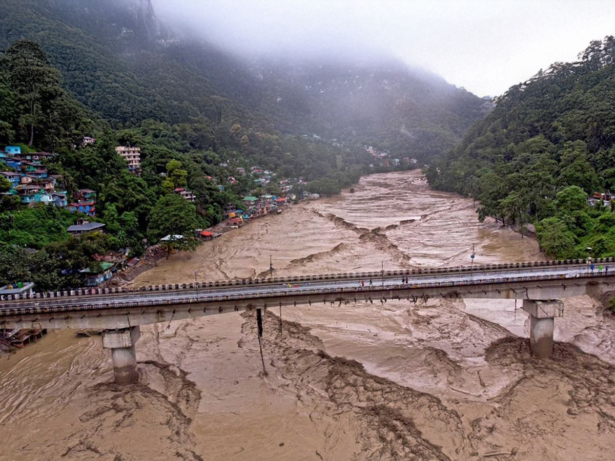
NEW DELHI — Confronted by the accelerating degradation of the Himalayan cryosphere, the government of India has initiated an aggressive structural emergency plan to mitigate the catastrophic threat of Glacial Lake Outburst Floods (GLOFs). Operating under the newly ratified National Glacial Lake Outburst Floods Risk Mitigation Programme (NGRMP), the National Disaster Management Authority (NDMA) has finalized a critical surveillance index identifying 189 high-risk glacial lakes requiring immediate intervention. This defensive environmental mobilization follows severe downstream destruction in Sikkim, where a sudden glacial lake breach caused approximately ₹18,000 crore in infrastructure damage and destroyed the vital Chungthang hydroelectric dam. With high-altitude atmospheric warming triggers expanding over 7,500 glacial water bodies across India’s northern borders, state agencies are launching physical alpine expeditions to implement early siphoning techniques, install automated warning systems, and fortify fragile natural moraine dams before the monsoonal surge.
Technical Mobilization in Inhospitable Terrains
According to official operational outlines published by the National Disaster Management Authority, specialized multi-agency engineering groups are executing physical site expeditions across Jammu and Kashmir, Ladakh, Himachal Pradesh, Uttarakhand, Sikkim, and Arunachal Pradesh. Field operatives are targeting the short seasonal window between July and September when high-altitude trails become accessible.
The structural interventions planned under the NGRMP focus on lowering the deep water volume of these expanding alpine lakes. By deploying artificial drainage channels and high-diameter siphon pipes, teams aim to mechanically lower water pressures exerted against porous, unstable moraine boundaries—natural dams formed by loose gravel, boulders, and glacial ice that are prone to sudden structural failure.
Cascading Impacts on Downstream Communities and Energy Sectors
The strategic necessity of defusing these high-risk glacial lakes extends far beyond high-altitude border ecology. A major glacial outburst carries severe implications for regional infrastructure, national energy security, and millions of downstream citizens living along the Indus, Ganges, and Brahmaputra river basins.
Data compiled by the Central Water Commission confirms that a sudden moraine collapse releases millions of cubic meters of water and debris within minutes, creating high-velocity mudflows capable of traveling over 100 kilometers. This poses an immediate threat to massive run-of-the-river hydroelectric installations, which supply clean power to India’s industrial grids. For local communities, investors, and state planners, these engineering interventions provide a vital shield for billions of dollars in critical infrastructure and safeguard the lives of vulnerable populations residing in low-lying river plains.
Official Sources Section
The institutional framework for this disaster management initiative is guided by remote sensing data provided by the Central Water Commission, which currently utilizes satellite surveillance to monitor 902 expanding high-altitude water bodies.
Detailing the extreme challenges of managing mountain cryosphere hazards, a scientific review published via the Indo-American Arts Council and regional disaster agencies stated:
"Fully assessing the interior volume and structural stability of moraine dams is only possible through direct, on-site physical expeditions. Satellite imaging identifies surface expansion, but field teams must physically ascend these inhospitable terrains to install Automated Weather and Water Level Monitoring Stations (AWWS) and Early Warning Systems (EWS). Securing real-time telemetry from these high-risk glacial lakes is critical to ensuring that downstream communities receive actionable evacuation windows before a major breach occurs."
Why It Matters
Mitigating high-risk glacial lakes is a vital priority for regional climate adaptation and infrastructure resilience. As rising global temperatures turn solid ice fields into volatile alpine reservoirs, relying purely on reactive relief operations is no longer viable.
By proactively lowering lake levels and integrating real-time telemetry with downstream civic alert networks, India is establishing a preventative model for high-altitude disaster risk reduction. This proactive framework protects public funds from devastating reconstruction costs, ensures uninterrupted clean energy generation, and provides long-term stability for civil populations living under the constant threat of sudden mountain floods.
Key Facts at a Glance
Target Index: The NDMA has identified 189 high-risk glacial lakes across the Himalayan range for immediate engineering intervention.
Structural Defense: Intervention strategies focus on lowering water levels through siphon piping and artificial channels to reduce pressure on unstable moraine dams.
Early Warning Integration: The national program will install automated weather stations and real-time water sensors to transmit instant alerts to downstream towns.
Massive Risk Exposure: The project helps safeguard billions of dollars in public infrastructure, dozens of hydroelectric plants, and millions of lives across northern river basins.
FAQ Section
What is a Glacial Lake Outburst Flood (GLOF)?
A GLOF occurs when a natural dam consisting of loose glacial moraine, ice, and rock debris suddenly breaches or overflows. This releases massive volumes of meltwater downstream at extreme speeds, often triggered by avalanches, earthquakes, or intense rainfall.
Why are these Himalayan glacial lakes becoming dangerous now?
Accelerated global warming is causing Himalayan glaciers to melt and retreat rapidly. This meltwater accumulates in unstable natural depressions, rapidly expanding the volume and pressure of these lakes against weak moraine boundaries.
How do engineers physically lower the water level of an alpine lake?
Field teams transport specialized equipment to high-altitude sites to cut open controlled artificial spillways or deploy heavy siphon pipes. These systems continuously drain the excess water, keeping lake volumes below critical breach thresholds.
Which Indian states are most vulnerable to these high-altitude floods?
The primary risk zones span the entire northern frontier, with critical high-risk lakes located across Sikkim, Arunachal Pradesh, Uttarakhand, Himachal Pradesh, Jammu and Kashmir, and Ladakh.
Source: Official disaster mitigation frameworks from the National Disaster Management Authority, remote sensing data reports from the Central Water Commission, and historical flood impact analyses archived by the Ministry of Finance.